|
search place name
|
||
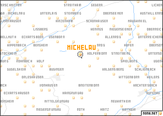
Michelau (Hessen, Germany)Michelau is a town in the Hessen region of Germany. An overview map of the region around Michelau is displayed below.
regional and 3d topo map of Michelau, Germany ::
Michelau airports ::
The nearest airport is ZNF - Hanau Aaf, located 23.4 km south west of Michelau.
Other airports nearby include FRA - Frankfurt Main (56.1 km south west), GHF - Giebelstadt Aaf (95.4 km south east), MHG - Mannheim City (106.6 km south west), ZNV - Koblenz Winningen (116.6 km west), Nearby towns ::
Bindsachsen (1.9km north) //
Rinderbügen (2.2km south east) //
Wolferborn (2.4km east) //
Kefenrod (3.0km north east) //
Gelnhaar (3.9km north) //
Wenings (6.0km north east) //
Büdingen (5.1km south west) //
Usenborn (5.1km north west) //
Breitenborn (7.5km south) //
Leisenwald (5.1km east) //
Dudenrod (5.1km west) //
Merkenfritz (7.5km north) //
Waldensberg (6.0km south east) //
Allenrod (6.0km north east) //
Schönhausen (7.8km north) //
Hirzenhain (7.8km north) //
Vonhausen (8.8km south west) //
Mittelseemen (8.8km north east) //
Lorbach (8.8km south west) //
[all distances 'as the bird flies' and approximate]  Places with similar names to Michelau, Germany ::
Disclaimer :: Information on this page comes without warranty of any kind |
||
|
Where is Michelau? Elevation and coordinates ::
Latitude (lat): 50°20'0"N Longitude (lon): 9°10'0"E
Elevation (approx.): 338m (map arrows pan, magnifying glasses zoom) |
||
|
Visiting Michelau? Hotel/Accommodation ::
Book a hotel in Michelau Travel Guide ::
Buy a travel guide for Germany rental cars ::
car rental offers GPS waypoint ::
download a GPX waypoint (PoI) of Michelau for your GPS receiver
|
||