|
search place name
|
||
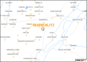
Neurochlitz (Brandenburg, Germany)Neurochlitz is a town in the Brandenburg region of Germany. An overview map of the region around Neurochlitz is displayed below.
regional and 3d topo map of Neurochlitz, Germany ::
Neurochlitz airports ::
The nearest airport is SZZ - Szczechin Goleniow, located 47.3 km north east of Neurochlitz.
Other airports nearby include TXL - Berlin Tegel (109.9 km south west), THF - Berlin Tempelhof (112.4 km south west), SXF - Berlin Schonefeld (116.6 km south west), IEG - Zielona Gora Babimost (158.6 km south east), Nearby towns ::
Rosow (2.2km north west) //
Neurosow (3.7km north) //
Staw (2.9km south east) //
Staffelde (2.9km south east) //
Geesow (3.9km south) //
Mescherin (4.3km south east) //
Freudenfeld (4.3km south west) //
Radekow (3.8km north west) //
Kołbaskowo (6.0km north) //
Damitzow (4.4km west) //
Keesow (4.8km south west) //
Tantow (4.8km south west) //
Pomellen (7.5km north) //
Nadrensee (6.5km north west) //
Moczyły (7.1km north east) //
Siadło Górne (8.1km north east) //
Neuenfeld (8.1km north west) //
Hohenreinkendorf (7.1km south west) //
[all distances 'as the bird flies' and approximate] 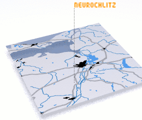 Places with similar names to Neurochlitz, Germany :: Disclaimer :: Information on this page comes without warranty of any kind |
||
|
Where is Neurochlitz? Elevation and coordinates ::
Latitude (lat): 53°17'0"N Longitude (lon): 14°24'0"E
Elevation (approx.): 24m (map arrows pan, magnifying glasses zoom) |
||
|
Visiting Neurochlitz? Hotel/Accommodation ::
Book a hotel in Neurochlitz Travel Guide ::
Buy a travel guide for Germany rental cars ::
car rental offers GPS waypoint ::
download a GPX waypoint (PoI) of Neurochlitz for your GPS receiver
|
||