|
search place name
|
||
Ohrwege (Niedersachsen, Germany)Ohrwege is a town in the Niedersachsen region of Germany. An overview map of the region around Ohrwege is displayed below.
regional and 3d topo map of Ohrwege, Germany ::

Ohrwege airports ::
The nearest airport is WVN - Wilhelmshaven Mariensiel, located 38.1 km north of Ohrwege.
Other airports nearby include EME - Emden (55.3 km north west), BRV - Bremerhaven (55.4 km north east), BRE - Bremen (56.5 km east), NRD - Norderney (77.5 km north west), Nearby towns ::
Altenkamp (0.0km north) //
Ekern (1.1km east) //
Rostruperfeld (1.9km north) //
Querenstede (1.9km south) //
Aschwege (1.9km south) //
Ohrwegerfeld (2.2km north west) //
Burgfelde (2.2km south east) //
Speckenerfeld (2.2km east) //
Specken (2.2km east) //
Deepenfurth (3.7km north) //
Dänikhorsterfeld (2.2km west) //
Brokhof (2.9km north east) //
Zwischenahnerfeld (2.9km north east) //
Bad Zwischenahn (2.9km north east) //
Rostrup (3.9km north) //
Im Vieh (3.9km south) //
Nord Edewecht (3.9km south) //
Edewecht (3.9km south) //
Viehdamm (3.9km south) //
Brink (3.9km south) //
Hemeler (3.9km south) //
Hösjekamp (4.3km north east) //
Vor dem Moore (4.3km south east) //
Portsloge (4.3km south east) //
Dänikhorst (4.3km south west) //
Willbroksmoor (5.6km north) //
Deyekamp (5.6km south) //
Kayhausermoor (3.3km east) //
Süd Edewecht (5.7km south) //
[all distances 'as the bird flies' and approximate] 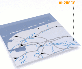 Places with similar names to Ohrwege, Germany :: Disclaimer :: Information on this page comes without warranty of any kind |
||
|
Where is Ohrwege? Elevation and coordinates ::
Latitude (lat): 53°10'0"N Longitude (lon): 7°58'0"E
Elevation (approx.): 9m (map arrows pan, magnifying glasses zoom) |
||
|
Visiting Ohrwege? Hotel/Accommodation ::
Book a hotel in Ohrwege Travel Guide ::
Buy a travel guide for Germany rental cars ::
car rental offers GPS waypoint ::
download a GPX waypoint (PoI) of Ohrwege for your GPS receiver
|
||