|
search place name
|
||
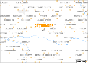
Ottendorf (Sachsen, Germany)Ottendorf is a town in the Sachsen region of Germany. An overview map of the region around Ottendorf is displayed below.
regional and 3d topo map of Ottendorf, Germany ::
Ottendorf airports ::
The nearest airport is BBJ - Bautzen, located 31.2 km north east of Ottendorf.
Other airports nearby include DRS - Dresden (42.5 km north west), PRG - Prague Ruzyne (94.5 km south), AOC - Altenburg Nobitz (126.0 km west), KLV - Karlovy Vary (128.6 km south west), Nearby towns ::
Saupsdorf (1.2km east) //
Hertigswalde (2.2km north west) //
Sebnitz (2.2km north west) //
Dolní Poustevna (3.7km north) //
Tomášov (2.3km east) //
Vilémov (3.0km north east) //
Horn (3.0km north west) //
Hölle (3.0km north west) //
Horní Poustevna (5.6km north) //
Marketa (5.6km north) //
Karlín (5.7km north) //
Hofhainersdorf (4.0km north west) //
Hinterhermsdorf (4.0km south east) //
Mikulášovice (4.7km east) //
Lichtenhain (4.7km west) //
Nová Víska (7.5km north) //
Amtshainersdorf (5.0km west) //
Ludvíkovičky (6.6km north east) //
Rugiswalde (6.6km north west) //
Schönbach (6.0km north west) //
Lipová (8.2km north east) //
Zadní Jetřichovice (7.3km south east) //
Schmilka (7.3km south west) //
[all distances 'as the bird flies' and approximate]  Places with similar names to Ottendorf, Germany ::
Disclaimer :: Information on this page comes without warranty of any kind |
||
|
Where is Ottendorf? Elevation and coordinates ::
Latitude (lat): 50°57'0"N Longitude (lon): 14°18'0"E
Elevation (approx.): 348m (map arrows pan, magnifying glasses zoom) |
||
|
Visiting Ottendorf? Hotel/Accommodation ::
Book a hotel in Ottendorf Travel Guide ::
Buy a travel guide for Germany rental cars ::
car rental offers GPS waypoint ::
download a GPX waypoint (PoI) of Ottendorf for your GPS receiver
|
||