|
search place name
|
||
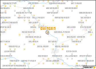
Owingen (Baden-Württemberg, Germany)Owingen is a town in the Baden-Württemberg region of Germany. An overview map of the region around Owingen is displayed below.
regional and 3d topo map of Owingen, Germany ::
Owingen airports ::
The nearest airport is ZQL - Donaueschingen Villingen, located 46.2 km south west of Owingen.
Other airports nearby include STR - Stuttgart (49.0 km north east), ZCC - Baden-baden Baden Oos (69.8 km north west), FDH - Friedrichshafen (89.3 km south east), SXB - Strassbourg Entzheim (92.0 km west), Nearby towns ::
Stetten (2.2km north west) //
Ostdorf (3.9km south) //
Seehof (3.9km north) //
Haigerloch (4.5km north west) //
Grosselfingen (3.7km east) //
Geislingen (5.7km south) //
Keimbachmühle (4.1km south west) //
Hart (5.7km north) //
Balingen (5.7km south) //
Gruol (4.1km north west) //
Karlstal (6.1km north west) //
Trillfingen (6.1km north west) //
Erlaheim (5.2km south west) //
Engstlatt (5.2km south east) //
Weildorf (5.2km north west) //
Kroppenhofen (4.9km west) //
Niederhofen (4.9km west) //
Höfendorf (7.5km north) //
Rangendingen (6.7km north east) //
Heselwangen (6.7km south east) //
Bittelbronn (7.4km north west) //
Bad Imnau (8.3km north west) //
[all distances 'as the bird flies' and approximate]  Places with similar names to Owingen, Germany ::
// Owingen (DE)
Disclaimer :: Information on this page comes without warranty of any kind |
||
|
Where is Owingen? Elevation and coordinates ::
Latitude (lat): 48°20'0"N Longitude (lon): 8°50'0"E
Elevation (approx.): 451m (map arrows pan, magnifying glasses zoom) |
||
|
Visiting Owingen? Hotel/Accommodation ::
Book a hotel in Owingen Travel Guide ::
Buy a travel guide for Germany rental cars ::
car rental offers GPS waypoint ::
download a GPX waypoint (PoI) of Owingen for your GPS receiver
|
||