|
search place name
|
||
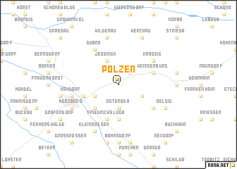
Polzen (Brandenburg, Germany)Polzen is a town in the Brandenburg region of Germany. An overview map of the region around Polzen is displayed below.
regional and 3d topo map of Polzen, Germany ::
Polzen airports ::
The nearest airport is DRS - Dresden, located 72.6 km south east of Polzen.
Other airports nearby include SXF - Berlin Schonefeld (75.4 km north), LEJ - Leipzig Halle (79.9 km south west), THF - Berlin Tempelhof (84.5 km north), TXL - Berlin Tegel (93.8 km north), Nearby towns ::
Kolochau (2.2km north east) //
Osteroda (3.7km south) //
Malitschkendorf (3.0km south east) //
Neunaundorf (3.0km south west) //
Jeßnigk (3.9km north) //
Friedersdorf (4.4km south west) //
Redlin (5.6km south) //
Weißenburg (3.9km north east) //
Friedrichsluga (5.7km south) //
Altherzberg (3.9km south west) //
Krassig (5.1km north east) //
Dubro (6.0km north) //
Jagsal (5.1km south east) //
Wildenau (7.5km north) //
Kaxdorf (5.0km west) //
Werchau (7.8km north) //
Neuhof (7.8km south) //
Kleinrössen (7.8km south) //
Oelsig (5.9km south east) //
Herzberg (5.9km south west) //
[all distances 'as the bird flies' and approximate] 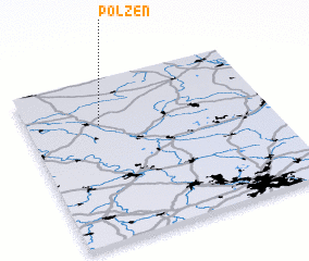 Places with similar names to Polzen, Germany ::
Disclaimer :: Information on this page comes without warranty of any kind |
||
|
Where is Polzen? Elevation and coordinates ::
Latitude (lat): 51°43'0"N Longitude (lon): 13°18'0"E
Elevation (approx.): 82m (map arrows pan, magnifying glasses zoom) |
||
|
Visiting Polzen? Hotel/Accommodation ::
Book a hotel in Polzen Travel Guide ::
Buy a travel guide for Germany rental cars ::
car rental offers GPS waypoint ::
download a GPX waypoint (PoI) of Polzen for your GPS receiver
|
||