|
search place name
|
||
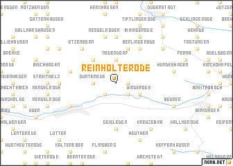
Reinholterode (Thüringen, Germany)Reinholterode is a town in the Thüringen region of Germany. An overview map of the region around Reinholterode is displayed below.
regional and 3d topo map of Reinholterode, Germany ::
Reinholterode airports ::
The nearest airport is KSF - Kassel Calden, located 57.2 km west of Reinholterode.
Other airports nearby include ERF - Erfurt (71.9 km south east), BWE - Braunschweig Wolfsburg (103.4 km north), PAD - Paderborn Lippstadt (112.1 km west), HAJ - Hannover (121.5 km north), Nearby towns ::
Steinbach (1.2km east) //
Westhausen (2.2km south west) //
Bodenrode (2.2km south east) //
Günterode (2.3km west) //
Neuendorf (3.7km north) //
Wingerode (3.0km south east) //
Glasehausen (4.4km north west) //
Bleckenrode (5.7km north) //
Berlingerode (6.0km north east) //
Böseckendorf (7.4km north) //
Geisleden (7.4km south) //
Nesselröden (7.5km north) //
Weißenborn (5.0km west) //
Etzenborn (6.6km north west) //
Immingerode (7.8km north) //
Heilbad Heiligenstadt (5.9km south west) //
Teistungen (7.2km north east) //
Kreuzebra (8.2km south east) //
Teistungenburg (8.7km north east) //
[all distances 'as the bird flies' and approximate] 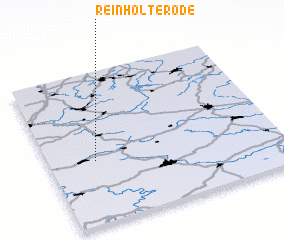 Places with similar names to Reinholterode, Germany :: Disclaimer :: Information on this page comes without warranty of any kind |
||
|
Where is Reinholterode? Elevation and coordinates ::
Latitude (lat): 51°25'0"N Longitude (lon): 10°12'0"E
Elevation (approx.): 315m (map arrows pan, magnifying glasses zoom) |
||
|
Visiting Reinholterode? Hotel/Accommodation ::
Book a hotel in Reinholterode Travel Guide ::
Buy a travel guide for Germany rental cars ::
car rental offers GPS waypoint ::
download a GPX waypoint (PoI) of Reinholterode for your GPS receiver
|
||