|
search place name
|
||
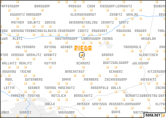
Rieda (Sachsen-Anhalt, Germany)Rieda is a town in the Sachsen-Anhalt region of Germany. An overview map of the region around Rieda is displayed below.
regional and 3d topo map of Rieda, Germany ::
Rieda airports ::
The nearest airport is LEJ - Leipzig Halle, located 22.2 km south east of Rieda.
Other airports nearby include AOC - Altenburg Nobitz (75.3 km south east), ERF - Erfurt (103.6 km south west), DRS - Dresden (129.3 km south east), BWE - Braunschweig Wolfsburg (131.1 km north west), Nearby towns ::
Siegelsdorf (0.0km north) //
Schrenz (1.9km south) //
Stumsdorf (1.9km north) //
Göttnitz (3.7km north) //
Hohen (3.7km south) //
Löbersdorf (3.9km north) //
Brachstedt (3.9km south) //
Wurp (3.9km south) //
Werben (3.0km north west) //
Mösslitz (4.4km north east) //
Eismannsdorf (4.4km south east) //
Mösthinsdorf (4.4km north west) //
Cösitz (5.6km north) //
Priesdorf (5.6km north) //
Spören (3.5km east) //
Prussendorf (3.5km east) //
Gölzau (5.7km north) //
Niemberg (5.7km south) //
Neusorge (5.7km south) //
Gödewitz (3.9km south east) //
Zörbig (5.1km north east) //
Radegast (6.0km north) //
Zeuendorf (6.0km north) //
Inwenden (6.0km south west) //
Harsdorf (6.0km south west) //
Oppin (6.0km south west) //
Weißandt-Gölzau (7.4km north) //
Großweißandt (7.4km north) //
Plößnitz (7.4km south) //
[all distances 'as the bird flies' and approximate] 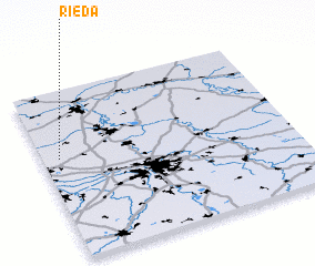 Places with similar names to Rieda, Germany ::
Disclaimer :: Information on this page comes without warranty of any kind |
||
|
Where is Rieda? Elevation and coordinates ::
Latitude (lat): 51°36'0"N Longitude (lon): 12°4'0"E
Elevation (approx.): 91m (map arrows pan, magnifying glasses zoom) |
||
|
Visiting Rieda? Hotel/Accommodation ::
Book a hotel in Rieda Travel Guide ::
Buy a travel guide for Germany rental cars ::
car rental offers GPS waypoint ::
download a GPX waypoint (PoI) of Rieda for your GPS receiver
|
||