|
search place name
|
||
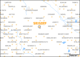
Saxdorf (Brandenburg, Germany)Saxdorf is a town in the Brandenburg region of Germany. An overview map of the region around Saxdorf is displayed below.
regional and 3d topo map of Saxdorf, Germany ::
Saxdorf airports ::
The nearest airport is DRS - Dresden, located 53.0 km south east of Saxdorf.
Other airports nearby include LEJ - Leipzig Halle (72.8 km west), AOC - Altenburg Nobitz (79.2 km south west), BBJ - Bautzen (92.6 km east), SXF - Berlin Schonefeld (99.3 km north), Nearby towns ::
Kauxdorf (2.2km north east) //
Marxdorf (3.7km north) //
Langenrieth (3.9km south) //
Bönitz (3.9km north) //
Neuburxdorf (3.9km south) //
Möglenz (3.5km east) //
Koßdorf (3.5km west) //
Wenzendorf (3.5km west) //
Burxdorf (5.7km south) //
Beiersdorf (5.7km north) //
Lehndorf (3.9km south west) //
Lönnewitz (5.1km north west) //
Wendisch Borschütz (7.4km south) //
Lausitz (5.0km east) //
Kosilenzien (6.6km south east) //
Zinsdorf (6.5km north east) //
Weinberge (6.6km south west) //
Brottewitz (5.9km south west) //
Schmerkendorf (7.8km north) //
Mühlberg (8.7km south west) //
[all distances 'as the bird flies' and approximate]  Places with similar names to Saxdorf, Germany ::
Disclaimer :: Information on this page comes without warranty of any kind |
||
|
Where is Saxdorf? Elevation and coordinates ::
Latitude (lat): 51°30'0"N Longitude (lon): 13°17'0"E
Elevation (approx.): 90m (map arrows pan, magnifying glasses zoom) |
||
|
Visiting Saxdorf? Hotel/Accommodation ::
Book a hotel in Saxdorf Travel Guide ::
Buy a travel guide for Germany rental cars ::
car rental offers GPS waypoint ::
download a GPX waypoint (PoI) of Saxdorf for your GPS receiver
|
||