|
search place name
|
||
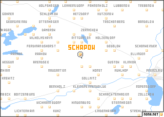
Schapow (Brandenburg, Germany)Schapow is a town in the Brandenburg region of Germany. An overview map of the region around Schapow is displayed below.
regional and 3d topo map of Schapow, Germany ::
Schapow airports ::
The nearest airport is SZZ - Szczechin Goleniow, located 83.0 km east of Schapow.
Other airports nearby include TXL - Berlin Tegel (92.6 km south), THF - Berlin Tempelhof (99.8 km south), SXF - Berlin Schonefeld (108.7 km south), RLG - Laage (114.2 km north west), Nearby towns ::
Schönermark (1.9km south) //
Wilhelmshof (2.2km south east) //
Rittgarten (3.7km north) //
Wittstock (3.9km north) //
Horst (4.3km south east) //
Zernickow (5.7km north) //
Gollmitz (5.7km south) //
Augustfelde (5.7km north) //
Christianenhof (3.8km north west) //
Falkenhagen (3.8km north east) //
Kraatz (5.0km north west) //
Holzendorf (5.0km north east) //
Naugarten (5.0km south west) //
Güstow (4.8km south east) //
Dedelow (4.8km north east) //
Klein Sperrenwalde (7.5km south) //
Kröchlendorf (7.5km south) //
Damerow (7.1km north west) //
Berkholz (8.1km south west) //
Taschenberg (8.6km north east) //
Jagow (8.6km north east) //
Ottenhagen (8.6km north west) //
[all distances 'as the bird flies' and approximate]  Places with similar names to Schapow, Germany ::
Disclaimer :: Information on this page comes without warranty of any kind |
||
|
Where is Schapow? Elevation and coordinates ::
Latitude (lat): 53°21'0"N Longitude (lon): 13°43'0"E
Elevation (approx.): 67m (map arrows pan, magnifying glasses zoom) |
||
|
Visiting Schapow? Hotel/Accommodation ::
Book a hotel in Schapow Travel Guide ::
Buy a travel guide for Germany rental cars ::
car rental offers GPS waypoint ::
download a GPX waypoint (PoI) of Schapow for your GPS receiver
|
||