|
search place name
|
||
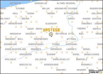
Upstede (Niedersachsen, Germany)Upstede is a town in the Niedersachsen region of Germany. An overview map of the region around Upstede is displayed below.
regional and 3d topo map of Upstede, Germany ::
Upstede airports ::
The nearest airport is WVN - Wilhelmshaven Mariensiel, located 24.0 km east of Upstede.
Other airports nearby include NRD - Norderney (35.0 km north west), EME - Emden (38.9 km south west), BRV - Bremerhaven (57.4 km east), BMK - Borkum (66.7 km west), Nearby towns ::
Burhafe (1.9km north) //
Kattrepel (1.9km north) //
Willen (2.2km south east) //
Angelsburg (2.2km south east) //
Kreyenburg (2.2km south east) //
Abens (2.2km north east) //
Burhafer Feldstrich (2.2km north west) //
Hattersum (2.2km east) //
Warnsather Feldstrich (2.2km west) //
Neudorf (3.7km north) //
Oldendorf (3.7km north) //
Uthörn (3.9km south) //
Blersum (2.9km north east) //
Heglitz (3.9km south) //
Negenbargen (2.9km south west) //
Neuwarfen (3.9km north) //
Buttforde (3.9km north) //
Warnsath (2.9km north west) //
Ost Dunum (3.3km west) //
Mammhusen (5.7km south) //
Hovel (5.7km south) //
Farlage (5.7km south) //
Updorf (3.8km south east) //
Jackstede (3.8km south west) //
Borgholt (5.7km south) //
Ardorf (5.7km south) //
Klosterneuenhaus (6.0km south) //
Webershausen (5.0km south west) //
Dumhusen (6.0km south) //
[all distances 'as the bird flies' and approximate] 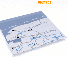 Places with similar names to Upstede, Germany ::
// Uppstad (NO)
Disclaimer :: Information on this page comes without warranty of any kind |
||
|
Where is Upstede? Elevation and coordinates ::
Latitude (lat): 53°35'0"N Longitude (lon): 7°43'0"E
Elevation (approx.): 1m (map arrows pan, magnifying glasses zoom) |
||
|
Visiting Upstede? Hotel/Accommodation ::
Book a hotel in Upstede Travel Guide ::
Buy a travel guide for Germany rental cars ::
car rental offers GPS waypoint ::
download a GPX waypoint (PoI) of Upstede for your GPS receiver
|
||