|
search place name
|
||
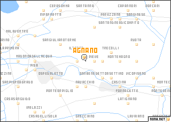
Agnano (Italy)Agnano is a town in Italy. An overview map of the region around Agnano is displayed below.
regional and 3d topo map of Agnano, Italy ::
Agnano airports ::
The nearest airport is PSA - Pisa, located 9.1 km south west of Agnano.
Other airports nearby include FLR - Firenze (58.7 km east), SAY - Siena Ampugnano (81.9 km south east), EBA - Marina Di Campo (109.9 km south), BLQ - Bologna (110.0 km north east), Nearby towns ::
Mezzana (1.3km west) //
Pieve (1.3km east) //
Il Prato (2.3km north west) //
Calci (2.7km east) //
San Benedetto a Settimo (4.6km south east) //
Navacchio (5.6km south) //
Casa Boulogne (5.7km south) //
Tre Colli (4.4km north east) //
Uliveto Terme (5.5km south east) //
San Giuliano Terme (5.5km north west) //
Montemagno (5.4km east) //
Badia Cantignano (7.5km north) //
Ospedaletto (6.5km south west) //
Ponte Arpiglio (8.4km south west) //
Cascina (7.7km south east) //
SantʼAndrea di Compito (9.1km north east) //
[all distances 'as the bird flies' and approximate]  Places with similar names to Agnano, Italy ::
Disclaimer :: Information on this page comes without warranty of any kind |
||
|
Where is Agnano? Elevation and coordinates ::
Latitude (lat): 43°44'0"N Longitude (lon): 10°29'0"E
Elevation (approx.): 30m (map arrows pan, magnifying glasses zoom) |
||
|
Visiting Agnano? Hotel/Accommodation ::
Book a hotel in Agnano Travel Guide ::
Buy a travel guide for Italy rental cars ::
car rental offers GPS waypoint ::
download a GPX waypoint (PoI) of Agnano for your GPS receiver
|
||