|
search place name
|
||
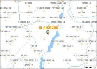
Albignano (Italy)Albignano is a town in Italy. An overview map of the region around Albignano is displayed below.
regional and 3d topo map of Albignano, Italy ::
Albignano airports ::
The nearest airport is LIN - Milan Linate, located 17.3 km west of Albignano.
Other airports nearby include BGY - Bergamo Orio Al Serio (25.9 km north east), MXP - Milano Malpensa (60.7 km west), VBS - Montichiari (66.7 km east), QPZ - Piacenza (67.9 km south), Nearby towns ::
Truccazzano (2.3km south west) //
Inzago (3.7km north) //
Cassano dʼAdda (4.5km north east) //
Rivolta dʼAdda (4.5km south east) //
Villa Fornaci (6.1km north west) //
Fara Gera dʼAdda (6.1km north east) //
Melzo (5.2km west) //
Liscate (5.5km west) //
Vaiano (6.8km south west) //
Comazzo (7.9km south) //
Agnadello (7.6km south east) //
Cambiago (9.1km north west) //
[all distances 'as the bird flies' and approximate] 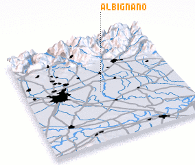 Places with similar names to Albignano, Italy :: Disclaimer :: Information on this page comes without warranty of any kind |
||
|
Where is Albignano? Elevation and coordinates ::
Latitude (lat): 45°30'0"N Longitude (lon): 9°29'0"E
Elevation (approx.): 114m (map arrows pan, magnifying glasses zoom) |
||
|
Visiting Albignano? Hotel/Accommodation ::
Book a hotel in Albignano Travel Guide ::
Buy a travel guide for Italy rental cars ::
car rental offers GPS waypoint ::
download a GPX waypoint (PoI) of Albignano for your GPS receiver
|
||