|
search place name
|
||
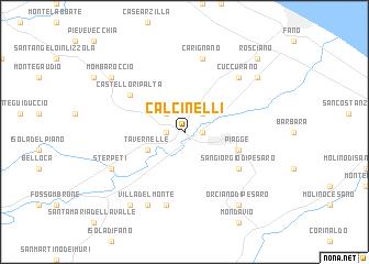
Calcinelli (Italy)Calcinelli is a town in Italy. An overview map of the region around Calcinelli is displayed below.
regional and 3d topo map of Calcinelli, Italy ::
Calcinelli airports ::
The nearest airport is RMI - Rimini, located 38.8 km north west of Calcinelli.
Other airports nearby include PEG - Perugia (79.7 km south west), FRL - Forli (84.0 km north west), FLR - Firenze (137.9 km west), SAY - Siena Ampugnano (145.1 km west), Nearby towns ::
Montemaggiore al Metauro (1.3km east) //
Saltara (1.3km west) //
Lucrezia (2.3km north east) //
La Pieve (2.3km north west) //
Tavernelle (3.3km south west) //
Piagge (4.4km south east) //
San Giorgio di Pesaro (5.5km south east) //
Castello Ripalta (5.5km north west) //
Carignano (7.5km north) //
Sorbolongo (7.5km south) //
Casa Allegretti (7.5km south) //
Cuccurano (6.9km north east) //
Sterpeti (6.5km south west) //
Villadelmonte (7.9km south) //
Bellocchi (7.7km north east) //
Orciano di Pesaro (8.4km south east) //
Mombaroccio (7.7km north west) //
SantʼIppolito (8.4km south west) //
Rosciano (9.1km north east) //
[all distances 'as the bird flies' and approximate] 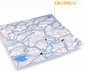 Places with similar names to Calcinelli, Italy :: Disclaimer :: Information on this page comes without warranty of any kind |
||
|
Where is Calcinelli? Elevation and coordinates ::
Latitude (lat): 43°45'0"N Longitude (lon): 12°55'0"E
Elevation (approx.): 64m (map arrows pan, magnifying glasses zoom) |
||
|
Visiting Calcinelli? Hotel/Accommodation ::
Book a hotel in Calcinelli Travel Guide ::
Buy a travel guide for Italy rental cars ::
car rental offers GPS waypoint ::
download a GPX waypoint (PoI) of Calcinelli for your GPS receiver
|
||