|
search place name
|
||
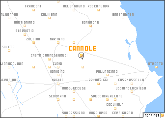
Cannole (Italy)Cannole is a town in Italy. An overview map of the region around Cannole is displayed below.
regional and 3d topo map of Cannole, Italy ::
Cannole airports ::
The nearest airport is LCC - Lecce, located 20.1 km north west of Cannole.
Other airports nearby include BDS - Brindisi Casale (64.4 km north west), TAR - Grottaglie (89.4 km north west), CFU - Kerkyra/corfu Ioannis Kapodistrias Intl (147.6 km south east), CRV - Crotone (169.6 km south west), Nearby towns ::
Serrano (1.9km north) //
Bagnolo del Salento (1.9km south) //
Carpignano Salentino (4.0km north) //
Cursi (4.6km south west) //
Palmariggi (6.2km south east) //
Martano (5.6km north west) //
Pallanzano (5.6km south east) //
Morigino (5.6km south west) //
Castrignano deʼ Greci (5.7km west) //
Borgagne (7.5km north) //
Muro Leccese (7.5km south) //
Melpignano (6.0km west) //
Maglie (7.0km south west) //
Giurdignano (7.9km south east) //
[all distances 'as the bird flies' and approximate]  Places with similar names to Cannole, Italy ::
Disclaimer :: Information on this page comes without warranty of any kind |
||
|
Where is Cannole? Elevation and coordinates ::
Latitude (lat): 40°10'0"N Longitude (lon): 18°21'0"E
Elevation (approx.): 92m (map arrows pan, magnifying glasses zoom) |
||
|
Visiting Cannole? Hotel/Accommodation ::
Book a hotel in Cannole Travel Guide ::
Buy a travel guide for Italy rental cars ::
car rental offers GPS waypoint ::
download a GPX waypoint (PoI) of Cannole for your GPS receiver
|
||