|
search place name
|
||
Cargalla (Italy)Cargalla is a town in Italy. An overview map of the region around Cargalla is displayed below.
regional and 3d topo map of Cargalla, Italy ::

Cargalla airports ::
The nearest airport is PMF - Parma, located 54.4 km north east of Cargalla.
Other airports nearby include QPZ - Piacenza (57.3 km north), GOA - Genoa Genova Sestri (86.0 km west), PSA - Pisa (89.9 km south east), BLQ - Bologna (110.0 km east), Nearby towns ::
Valdantena Casalina (1.3km east) //
Polina (2.3km north west) //
Ceretoli (3.7km south) //
Gravagna (4.6km north east) //
Santissima Annunziata (5.7km south) //
Pontremoli (6.2km south west) //
Scorcetoli (7.4km south) //
Grondola (5.3km west) //
Bratto (6.5km north west) //
Vignola (6.5km south west) //
Dozzano (7.7km south west) //
Cavezzana Gordana (7.7km south west) //
[all distances 'as the bird flies' and approximate] 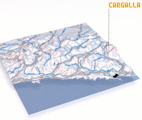 Places with similar names to Cargalla, Italy ::
Disclaimer :: Information on this page comes without warranty of any kind |
||
|
Where is Cargalla? Elevation and coordinates ::
Latitude (lat): 44°25'0"N Longitude (lon): 9°55'0"E
Elevation (approx.): 426m (map arrows pan, magnifying glasses zoom) |
||
|
Visiting Cargalla? Hotel/Accommodation ::
Book a hotel in Cargalla Travel Guide ::
Buy a travel guide for Italy rental cars ::
car rental offers GPS waypoint ::
download a GPX waypoint (PoI) of Cargalla for your GPS receiver
|
||