|
search place name
|
||
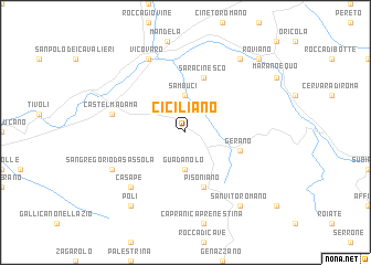
Ciciliano (Italy)Ciciliano is a town in Italy. An overview map of the region around Ciciliano is displayed below.
regional and 3d topo map of Ciciliano, Italy ::
Ciciliano airports ::
The nearest airport is CIA - Rome Ciampino, located 32.7 km south west of Ciciliano.
Other airports nearby include QLT - Latina (45.3 km south), FCO - Rome Fiumicino (58.9 km west), PSR - Pescara (116.1 km north east), PEG - Perugia (131.9 km north), Nearby towns ::
Sambuci (3.7km north) //
Guadanolo (3.7km south) //
Saracinesco (5.7km north) //
Gerano (4.5km south east) //
Cerreto Laziale (4.5km south east) //
Pisoniano (5.7km south) //
Castel Madama (5.8km west) //
Casape (6.9km south west) //
San Gregorio da Sassola (6.6km south west) //
Vicovaro (7.9km north) //
Anticoli Corrado (8.5km north east) //
Poli (8.5km south west) //
San Vito Romano (8.5km south east) //
Roviano (9.2km north east) //
[all distances 'as the bird flies' and approximate]  Places with similar names to Ciciliano, Italy ::
// Seysulan (AZ)
// Zaselino (RU)
// Zuslany (RU)
// Soussillon (CH)
// Siselen (CH)
// Sassoleone (IT)
// Cieślin (PL)
// Cieślin (PL)
// Szyleny (PL)
// Zezulin (PL)
Disclaimer :: Information on this page comes without warranty of any kind |
||
|
Where is Ciciliano? Elevation and coordinates ::
Latitude (lat): 41°57'0"N Longitude (lon): 12°56'0"E
Elevation (approx.): 452m (map arrows pan, magnifying glasses zoom) |
||
|
Visiting Ciciliano? Hotel/Accommodation ::
Book a hotel in Ciciliano Travel Guide ::
Buy a travel guide for Italy rental cars ::
car rental offers GPS waypoint ::
download a GPX waypoint (PoI) of Ciciliano for your GPS receiver
|
||