|
search place name
|
||
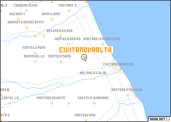
Civitanova Alta (Italy)Civitanova Alta is a town in Italy. An overview map of the region around Civitanova Alta is displayed below.
regional and 3d topo map of Civitanova Alta, Italy ::
Civitanova Alta airports ::
The nearest airport is PEG - Perugia, located 96.9 km west of Civitanova Alta.
Other airports nearby include PSR - Pescara (106.9 km south east), RMI - Rimini (115.5 km north west), FRL - Forli (161.4 km north west), ZAD - Zadar (161.5 km north east), Nearby towns ::
Cascina Monte Serico (1.9km north) //
Elviano (2.3km north east) //
Molino Ciccolini (3.9km south) //
Porto Potenza Picena (4.6km north east) //
Monte Canepino (4.6km north west) //
Montecosaro (4.0km west) //
Civitanova Marche (5.7km east) //
Potenza Picena (6.9km north west) //
[all distances 'as the bird flies' and approximate]  Places with similar names to Civitanova Alta, Italy :: Disclaimer :: Information on this page comes without warranty of any kind |
||
|
Where is Civitanova Alta? Elevation and coordinates ::
Latitude (lat): 43°19'0"N Longitude (lon): 13°40'0"E
Elevation (approx.): 98m (map arrows pan, magnifying glasses zoom) |
||
|
Visiting Civitanova Alta? Hotel/Accommodation ::
Book a hotel in Civitanova Alta Travel Guide ::
Buy a travel guide for Italy rental cars ::
car rental offers GPS waypoint ::
download a GPX waypoint (PoI) of Civitanova Alta for your GPS receiver
|
||