|
search place name
|
||
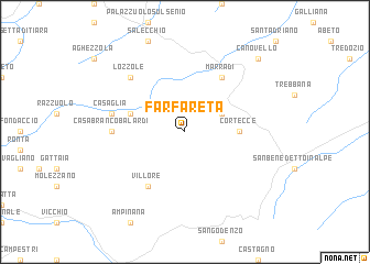
Farfareta (Italy)Farfareta is a town in Italy. An overview map of the region around Farfareta is displayed below.
regional and 3d topo map of Farfareta, Italy ::
Farfareta airports ::
The nearest airport is FLR - Firenze, located 38.1 km south west of Farfareta.
Other airports nearby include FRL - Forli (43.7 km north east), BLQ - Bologna (62.3 km north), RMI - Rimini (82.5 km east), SAY - Siena Ampugnano (88.5 km south), Nearby towns ::
Albero (3.2km north east) //
Cortecce (4.0km east) //
Crespino del Lamone (4.4km north west) //
Villore (6.2km south west) //
Marradi (6.2km north east) //
Casa Brancobalardi (5.3km west) //
Casaglia (5.6km west) //
Lozzole (6.8km north west) //
Canovello (9.1km north east) //
[all distances 'as the bird flies' and approximate]  Places with similar names to Farfareta, Italy ::
// Fairford (US)
// Vorfrutt (CH)
// Fürfurt (DE)
// Fravert (US)
// Varvariáda (GR)
// Vera Verde (VE)
// Farafaradiè (ML)
// Verghereto (IT)
// Fairford (CA)
// Fairford (GB)
Disclaimer :: Information on this page comes without warranty of any kind |
||
|
Where is Farfareta? Elevation and coordinates ::
Latitude (lat): 44°1'0"N Longitude (lon): 11°35'0"E
Elevation (approx.): 600m (map arrows pan, magnifying glasses zoom) |
||
|
Visiting Farfareta? Hotel/Accommodation ::
Book a hotel in Farfareta Travel Guide ::
Buy a travel guide for Italy rental cars ::
car rental offers GPS waypoint ::
download a GPX waypoint (PoI) of Farfareta for your GPS receiver
|
||