|
search place name
|
||
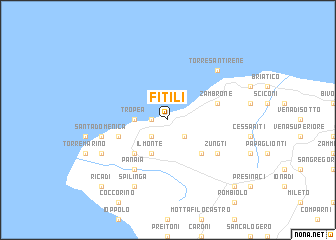
Fitili (Italy)Fitili is a town in Italy. An overview map of the region around Fitili is displayed below.
regional and 3d topo map of Fitili, Italy ::
Fitili airports ::
The nearest airport is SUF - Lamezia Terme, located 36.4 km north east of Fitili.
Other airports nearby include REG - Reggio Calabria (72.3 km south), CRV - Crotone (105.5 km east), CTA - Catania Fontanarossa (155.0 km south west), NSY - Sigonella (167.7 km south west), Nearby towns ::
Parghelia (1.4km west) //
SantʼAgata (2.4km south west) //
Drapia (2.4km south west) //
Zaccanopoli (2.4km south east) //
Tropea (2.9km west) //
Il Monte (4.0km south) //
Caria (4.7km south west) //
Casa dʼAcquino (4.7km south east) //
Ciaramiti (4.7km south west) //
Zambrone (4.7km north east) //
Mandaradoni (4.7km north east) //
Casa Nucara (5.7km south east) //
Zungti (5.7km south east) //
Panaia (6.3km south west) //
Santa Domenica (6.1km west) //
Torre SantʼIrene (7.1km north east) //
Spilinga (8.0km south) //
Orsigliadi (6.9km south west) //
Ricadi (9.4km south west) //
Le Pioppe (9.4km south east) //
[all distances 'as the bird flies' and approximate]  Places with similar names to Fitili, Italy ::
Disclaimer :: Information on this page comes without warranty of any kind |
||
|
Where is Fitili? Elevation and coordinates ::
Latitude (lat): 38°41'0"N Longitude (lon): 15°56'0"E
Elevation (approx.): 189m (map arrows pan, magnifying glasses zoom) |
||
|
Visiting Fitili? Hotel/Accommodation ::
Book a hotel in Fitili Travel Guide ::
Buy a travel guide for Italy rental cars ::
car rental offers GPS waypoint ::
download a GPX waypoint (PoI) of Fitili for your GPS receiver
|
||