|
search place name
|
||
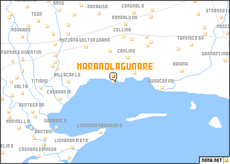
Marano Lagunare (Friuli-Venezia Giulia, Italy)Marano Lagunare is a town in the Friuli-Venezia Giulia region of Italy. An overview map of the region around Marano Lagunare is displayed below.
regional and 3d topo map of Marano Lagunare, Italy ::
Marano Lagunare airports ::
The nearest airport is TRS - Ronchi De Legionari Ronchi Dei Legionari, located 24.5 km east of Marano Lagunare.
Other airports nearby include POW - Portoroz (47.6 km south east), AVB - Aviano Ab (Pagliano E Gori) (53.3 km north west), VCE - Venice Venezia Tessera (70.0 km south west), TSF - Treviso (77.0 km west), Nearby towns ::
Marano (0.2km west) //
Villa Bruna (2.7km north east) //
Carlino (4.2km north) //
San Gervásio (5.2km north) //
Galli (7.2km north) //
Muzzana del Turgnano (6.7km north west) //
Zellina (7.5km north) //
Villa Carlo (5.4km west) //
Áusa-Corno (5.4km east) //
Nogaro (7.0km north east) //
Lignano Sabbiadoro (8.4km south) //
Villanova (7.7km north east) //
San Giórgio di Nogaro (8.3km north east) //
Pocenia (9.5km north west) //
[all distances 'as the bird flies' and approximate] 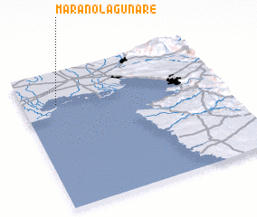 Places with similar names to Marano Lagunare, Italy :: Disclaimer :: Information on this page comes without warranty of any kind |
||
|
Where is Marano Lagunare? Elevation and coordinates ::
Latitude (lat): 45°45'59"N Longitude (lon): 13°10'9"E
Elevation (approx.): 1m (map arrows pan, magnifying glasses zoom) |
||
|
Visiting Marano Lagunare? Hotel/Accommodation ::
Book a hotel in Marano Lagunare Travel Guide ::
Buy a travel guide for Italy rental cars ::
car rental offers GPS waypoint ::
download a GPX waypoint (PoI) of Marano Lagunare for your GPS receiver
|
||