|
search place name
|
||
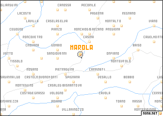
Marola (Italy)Marola is a town in Italy. An overview map of the region around Marola is displayed below.
regional and 3d topo map of Marola, Italy ::
Marola airports ::
The nearest airport is PMF - Parma, located 40.7 km north of Marola.
Other airports nearby include BLQ - Bologna (64.3 km east), QPZ - Piacenza (76.9 km north west), PSA - Pisa (89.1 km south), FLR - Firenze (94.5 km south east), Nearby towns ::
Migliara (1.9km north) //
Casina (3.9km north) //
Pietradura (4.6km south west) //
Carpineti (4.6km south east) //
San Giovanni (4.0km west) //
Casa del Lago (5.6km north) //
Spignana (5.7km south) //
Gombio (4.4km north west) //
Monchio di Sarzano (5.7km north) //
Onfiano (5.3km east) //
Vesallo (6.8km south east) //
Pianzo (6.8km north west) //
Casale di Bismantova (7.9km south) //
Case la Selva (8.4km north west) //
Prediera (7.7km north east) //
Montalto (9.1km north east) //
[all distances 'as the bird flies' and approximate]  Places with similar names to Marola, Italy ::
Disclaimer :: Information on this page comes without warranty of any kind |
||
|
Where is Marola? Elevation and coordinates ::
Latitude (lat): 44°29'0"N Longitude (lon): 10°29'0"E
Elevation (approx.): 784m (map arrows pan, magnifying glasses zoom) |
||
|
Visiting Marola? Hotel/Accommodation ::
Book a hotel in Marola Travel Guide ::
Buy a travel guide for Italy rental cars ::
car rental offers GPS waypoint ::
download a GPX waypoint (PoI) of Marola for your GPS receiver
|
||