|
search place name
|
||
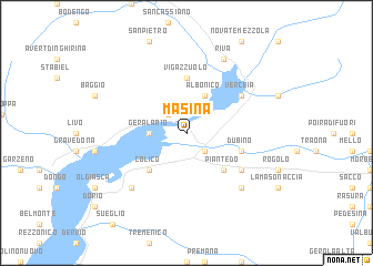
Masina (Italy)Masina is a town in Italy. An overview map of the region around Masina is displayed below.
regional and 3d topo map of Masina, Italy ::
Masina airports ::
The nearest airport is LUG - Lugano, located 41.9 km south west of Masina.
Other airports nearby include SMV - Samedan (55.3 km north east), BGY - Bergamo Orio Al Serio (59.6 km south east), MXP - Milano Malpensa (79.2 km south west), LIN - Milan Linate (80.8 km south), Nearby towns ::
Bugiallo (2.3km north west) //
Cresciasca (2.3km south east) //
Gera Lario (2.6km west) //
Albonico (3.9km north) //
Piantedo (4.5km south east) //
Colico (4.5km south west) //
Vigazzuolo (5.6km north) //
Dubino (4.3km south east) //
Verceia (5.3km north east) //
Delebio (5.3km south east) //
Canargo (6.8km south east) //
Carriola (6.8km south west) //
Riva (7.8km north) //
[all distances 'as the bird flies' and approximate] 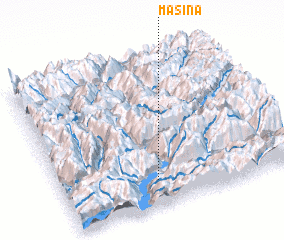 Places with similar names to Masina, Italy ::
Disclaimer :: Information on this page comes without warranty of any kind |
||
|
Where is Masina? Elevation and coordinates ::
Latitude (lat): 46°10'0"N Longitude (lon): 9°24'0"E
Elevation (approx.): 199m (map arrows pan, magnifying glasses zoom) |
||
|
Visiting Masina? Hotel/Accommodation ::
Book a hotel in Masina Travel Guide ::
Buy a travel guide for Italy rental cars ::
car rental offers GPS waypoint ::
download a GPX waypoint (PoI) of Masina for your GPS receiver
|
||