|
search place name
|
||
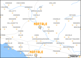
Montale (Italy)Montale is a town in Italy. An overview map of the region around Montale is displayed below.
regional and 3d topo map of Montale, Italy ::
Montale airports ::
The nearest airport is GOA - Genoa Genova Sestri, located 64.7 km west of Montale.
Other airports nearby include QPZ - Piacenza (68.5 km north), PMF - Parma (78.6 km north east), PSA - Pisa (91.6 km south east), ALL - Albenga (123.6 km west), Nearby towns ::
Lisorno (2.3km north east) //
Rio (2.7km east) //
Ziona (3.9km south) //
Sesta Godano (3.2km south east) //
Carro (4.6km south west) //
Carrodano Superiore (5.6km south) //
Mattarana (5.7km south) //
Pizzolo (5.7km north) //
San Pietro Vara (5.4km north west) //
Varese Ligure (7.5km north) //
Scogna Superiore (5.6km east) //
Carrodano Inferiore (7.5km south) //
Pignona (5.6km east) //
Chiusola (6.5km north east) //
Mangia (7.7km south east) //
[all distances 'as the bird flies' and approximate] 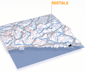 Places with similar names to Montale, Italy ::
Disclaimer :: Information on this page comes without warranty of any kind |
||
|
Where is Montale? Elevation and coordinates ::
Latitude (lat): 44°18'0"N Longitude (lon): 9°38'0"E
Elevation (approx.): 433m (map arrows pan, magnifying glasses zoom) |
||
|
Visiting Montale? Hotel/Accommodation ::
Book a hotel in Montale Travel Guide ::
Buy a travel guide for Italy rental cars ::
car rental offers GPS waypoint ::
download a GPX waypoint (PoI) of Montale for your GPS receiver
|
||