|
search place name
|
||
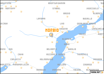
Morbio (Italy)Morbio is a town in Italy. An overview map of the region around Morbio is displayed below.
regional and 3d topo map of Morbio, Italy ::
Morbio airports ::
The nearest airport is LUG - Lugano, located 31.1 km south west of Morbio.
Other airports nearby include BGY - Bergamo Orio Al Serio (61.3 km south east), SMV - Samedan (65.1 km north east), MXP - Milano Malpensa (69.8 km south west), LIN - Milan Linate (76.5 km south), Nearby towns ::
Musso (1.9km south) //
Garzeno (1.3km west) //
Dongo (2.3km south east) //
Gravedona (3.2km north east) //
Livo (4.5km north east) //
Belmonte (5.6km south) //
Olgiasca (4.3km south east) //
Domaso (4.3km north east) //
Dorio (5.3km south east) //
La Foppa (6.1km north west) //
Rezzonico (7.4km south) //
Dervio (7.8km south) //
Sueglio (7.6km south east) //
Baggio (8.4km north east) //
[all distances 'as the bird flies' and approximate] 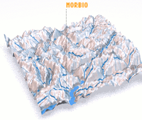 Places with similar names to Morbio, Italy ::
Disclaimer :: Information on this page comes without warranty of any kind |
||
|
Where is Morbio? Elevation and coordinates ::
Latitude (lat): 46°8'0"N Longitude (lon): 9°16'0"E
Elevation (approx.): 438m (map arrows pan, magnifying glasses zoom) |
||
|
Visiting Morbio? Hotel/Accommodation ::
Book a hotel in Morbio Travel Guide ::
Buy a travel guide for Italy rental cars ::
car rental offers GPS waypoint ::
download a GPX waypoint (PoI) of Morbio for your GPS receiver
|
||