|
search place name
|
||
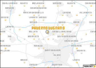
Paderno Dugnano (Italy)Paderno Dugnano is a town in Italy. An overview map of the region around Paderno Dugnano is displayed below.
regional and 3d topo map of Paderno Dugnano, Italy ::
Paderno Dugnano airports ::
The nearest airport is LIN - Milan Linate, located 14.5 km south east of Paderno Dugnano.
Other airports nearby include MXP - Milano Malpensa (35.4 km west), BGY - Bergamo Orio Al Serio (44.1 km east), LUG - Lugano (54.3 km north), QPZ - Piacenza (83.2 km south east), Nearby towns ::
Cusano Milanino (1.3km east) //
Brusuglio (1.9km south) //
Cormano (1.9km south) //
Bruzzano (2.3km south east) //
Bresso (2.3km south east) //
Ospitaletto (2.3km south west) //
Bugnano (2.3km north west) //
Novate Milanese (3.2km south west) //
Nova Milanese (4.5km north east) //
Cinisello Balsamo (3.9km east) //
Bollate (3.9km west) //
Bovisa (5.7km south) //
Baranzate (4.3km south west) //
Varedo (5.7km north) //
Muggiò (5.4km north east) //
Senago (5.4km north west) //
Musocco (6.1km south west) //
Sesto San Giovanni (5.5km east) //
Quarto Oggiaro (7.5km south) //
Limbiate (6.8km north west) //
Bovisio Masciago (7.9km north) //
Desio (8.4km north east) //
Manicomio Mombello (8.4km north west) //
Lissone (9.0km north east) //
[all distances 'as the bird flies' and approximate]  Places with similar names to Paderno Dugnano, Italy :: Disclaimer :: Information on this page comes without warranty of any kind |
||
|
Where is Paderno Dugnano? Elevation and coordinates ::
Latitude (lat): 45°33'0"N Longitude (lon): 9°10'0"E
Elevation (approx.): 155m (map arrows pan, magnifying glasses zoom) |
||
|
Visiting Paderno Dugnano? Hotel/Accommodation ::
Book a hotel in Paderno Dugnano Travel Guide ::
Buy a travel guide for Italy rental cars ::
car rental offers GPS waypoint ::
download a GPX waypoint (PoI) of Paderno Dugnano for your GPS receiver
|
||