|
search place name
|
||
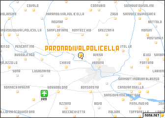
Parona di Valpolicella (Italy)Parona di Valpolicella is a town in Italy. An overview map of the region around Parona di Valpolicella is displayed below.
regional and 3d topo map of Parona di Valpolicella, Italy ::
Parona di Valpolicella airports ::
The nearest airport is VRN - Villafranca, located 10.0 km south west of Parona di Valpolicella.
Other airports nearby include VIC - Vicenza (45.6 km east), VBS - Montichiari (49.9 km west), QPA - Padova (69.4 km east), PMF - Parma (88.7 km south west), Nearby towns ::
Avesa (2.6km east) //
Poiano (2.6km east) //
Verona (3.2km south east) //
Chievo (3.2km south west) //
Montecchio (5.6km north) //
Santa Maria in Stelle (5.5km east) //
Borgo Roma (7.5km south) //
San Pancrazio (6.8km south east) //
San Floriano (6.8km north west) //
Grezzana (6.8km north east) //
Negrar (8.4km north west) //
Dossobuono (8.4km south west) //
[all distances 'as the bird flies' and approximate] 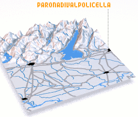 Places with similar names to Parona di Valpolicella, Italy :: Disclaimer :: Information on this page comes without warranty of any kind |
||
|
Where is Parona di Valpolicella? Elevation and coordinates ::
Latitude (lat): 45°28'0"N Longitude (lon): 10°58'0"E
Elevation (approx.): 88m (map arrows pan, magnifying glasses zoom) |
||
|
Visiting Parona di Valpolicella? Hotel/Accommodation ::
Book a hotel in Parona di Valpolicella Travel Guide ::
Buy a travel guide for Italy rental cars ::
car rental offers GPS waypoint ::
download a GPX waypoint (PoI) of Parona di Valpolicella for your GPS receiver
|
||