|
search place name
|
||
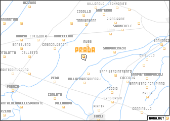
Prada (Emilia-Romagna, Italy)Prada is a town in the Emilia-Romagna region of Italy. An overview map of the region around Prada is displayed below.
regional and 3d topo map of Prada, Italy ::
Prada airports ::
The nearest airport is FRL - Forli, located 16.8 km south of Prada.
Other airports nearby include RMI - Rimini (58.9 km south east), BLQ - Bologna (62.5 km west), FLR - Firenze (88.5 km south west), QPA - Padova (117.9 km north), Nearby towns ::
Casa Foschini (3.0km south) //
Russi (3.3km north) //
Villafranca di Forlì (4.9km south) //
Boncellino (5.7km north west) //
San Pancrazio (5.0km east) //
Casa Calderoni (5.4km north west) //
San Pietro in Trento (5.8km south east) //
Traversara (8.0km north) //
Godo (7.1km north east) //
Reda (6.7km south west) //
Birandola (6.7km south west) //
Bagnacavallo (8.5km north) //
Poggio (8.3km south east) //
Piangipane (9.6km north east) //
Corleto (9.7km south west) //
San Michele (9.1km north east) //
[all distances 'as the bird flies' and approximate] 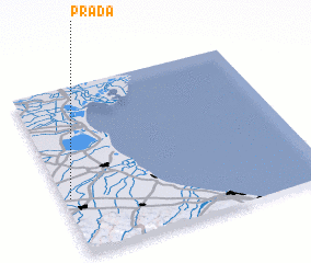 Places with similar names to Prada, Italy ::
Disclaimer :: Information on this page comes without warranty of any kind |
||
|
Where is Prada? Elevation and coordinates ::
Latitude (lat): 44°20'34"N Longitude (lon): 12°1'35"E
Elevation (approx.): 9m (map arrows pan, magnifying glasses zoom) |
||
|
Visiting Prada? Hotel/Accommodation ::
Book a hotel in Prada Travel Guide ::
Buy a travel guide for Italy rental cars ::
car rental offers GPS waypoint ::
download a GPX waypoint (PoI) of Prada for your GPS receiver
|
||