|
search place name
|
||
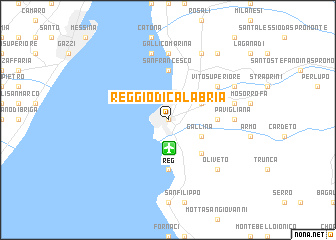
Reggio di Calabria (Calabria, Italy)Reggio di Calabria is a town in the Calabria region of Italy. An overview map of the region around Reggio di Calabria is displayed below.
regional and 3d topo map of Reggio di Calabria, Italy ::
Reggio di Calabria airports ::
The nearest airport is REG - Reggio Calabria, located 3.2 km south of Reggio di Calabria.
Other airports nearby include CTA - Catania Fontanarossa (87.1 km south west), NSY - Sigonella (100.6 km south west), SUF - Lamezia Terme (103.3 km north east), CRV - Crotone (159.6 km north east), Nearby towns ::
Sbarre (0.0km north) //
San Gregorio (3.7km south) //
Vito Inferiore (3.5km north east) //
Gallina (3.5km south east) //
Croce Valanidi (4.7km south east) //
San Francesco (5.6km north) //
Archi (5.6km north) //
Arangea (4.4km east) //
Occhio (5.6km south) //
Vito (5.7km north east) //
Vito Superiore (5.7km north east) //
Gallico Marina (7.4km north) //
Pavigliana (5.8km east) //
Fontanelli (7.6km north) //
Terreti (6.1km east) //
Oliveto (7.1km south east) //
Orti (6.9km north east) //
Trizzino (6.9km north east) //
Gallico (8.0km north) //
San Giovanni (8.6km north east) //
[all distances 'as the bird flies' and approximate]  Places with similar names to Reggio di Calabria, Italy :: Disclaimer :: Information on this page comes without warranty of any kind |
||
|
Where is Reggio di Calabria? Elevation and coordinates ::
Latitude (lat): 38°6'0"N Longitude (lon): 15°39'0"E
Elevation (approx.): 41m (map arrows pan, magnifying glasses zoom) |
||
|
Visiting Reggio di Calabria? Hotel/Accommodation ::
Book a hotel in Reggio di Calabria Travel Guide ::
Buy a travel guide for Italy rental cars ::
car rental offers GPS waypoint ::
download a GPX waypoint (PoI) of Reggio di Calabria for your GPS receiver
|
||