|
search place name
|
||
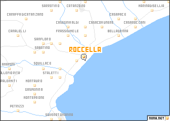
Roccella (Italy)Roccella is a town in Italy. An overview map of the region around Roccella is displayed below.
regional and 3d topo map of Roccella, Italy ::
Roccella airports ::
The nearest airport is SUF - Lamezia Terme, located 33.2 km west of Roccella.
Other airports nearby include CRV - Crotone (47.1 km north east), REG - Reggio Calabria (115.8 km south west), CTA - Catania Fontanarossa (199.9 km south west), TAR - Grottaglie (202.8 km north), Nearby towns ::
Golino (1.4km west) //
Marina di Catanzaro (1.9km north) //
Corvo (5.6km north) //
Ceraso (4.7km south west) //
Copanello (5.7km south west) //
Giardinello (5.7km north west) //
Frassi di Mele (6.3km north west) //
Santa Maria (7.4km north) //
Stalettì (6.9km south west) //
Casa Maio (6.9km south west) //
Case Sansone (6.9km north west) //
Casa Comunere (8.0km north) //
Case Grimaldi (8.0km north) //
Belladonna (8.0km north east) //
[all distances 'as the bird flies' and approximate] 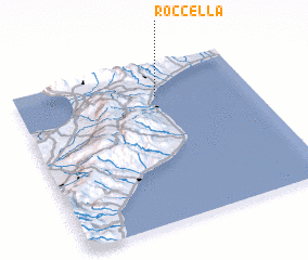 Places with similar names to Roccella, Italy ::
Disclaimer :: Information on this page comes without warranty of any kind |
||
|
Where is Roccella? Elevation and coordinates ::
Latitude (lat): 38°48'0"N Longitude (lon): 16°36'0"E
Elevation (approx.): -32768m (map arrows pan, magnifying glasses zoom) |
||
|
Visiting Roccella? Hotel/Accommodation ::
Book a hotel in Roccella Travel Guide ::
Buy a travel guide for Italy rental cars ::
car rental offers GPS waypoint ::
download a GPX waypoint (PoI) of Roccella for your GPS receiver
|
||