|
search place name
|
||
San Paolo (Italy)San Paolo is a town in Italy. An overview map of the region around San Paolo is displayed below.
regional and 3d topo map of San Paolo, Italy ::

San Paolo airports ::
The nearest airport is TRN - Torino, located 16.8 km north of San Paolo.
Other airports nearby include CUF - Levaldigi (55.9 km south), MXP - Milano Malpensa (107.4 km north east), ALL - Albenga (117.8 km south), GOA - Genoa Genova Sestri (118.8 km south east), Nearby towns ::
Lingotto (2.3km south east) //
Mirafiori (3.7km south) //
Torino (2.6km east) //
Millefonti (3.2km south east) //
Grugliasco (4.3km north west) //
Regina Margherita (4.3km north west) //
Ceronda (5.7km north) //
Beinasco (5.4km south west) //
Nichelino (7.4km south) //
Borgo Po (5.2km east) //
Moncalieri (6.8km south east) //
Collegno (6.4km north west) //
Stupinigi (7.9km south) //
Falchera (9.1km north east) //
[all distances 'as the bird flies' and approximate] 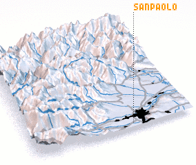 Places with similar names to San Paolo, Italy ::
Disclaimer :: Information on this page comes without warranty of any kind |
||
|
Where is San Paolo? Elevation and coordinates ::
Latitude (lat): 45°3'0"N Longitude (lon): 7°38'0"E
Elevation (approx.): 262m (map arrows pan, magnifying glasses zoom) |
||
|
Visiting San Paolo? Hotel/Accommodation ::
Book a hotel in San Paolo Travel Guide ::
Buy a travel guide for Italy rental cars ::
car rental offers GPS waypoint ::
download a GPX waypoint (PoI) of San Paolo for your GPS receiver
|
||