|
search place name
|
||
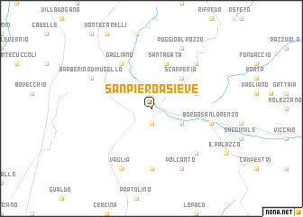
San Piero a Sieve (Italy)San Piero a Sieve is a town in Italy. An overview map of the region around San Piero a Sieve is displayed below.
regional and 3d topo map of San Piero a Sieve, Italy ::
San Piero a Sieve airports ::
The nearest airport is FLR - Firenze, located 19.6 km south west of San Piero a Sieve.
Other airports nearby include BLQ - Bologna (63.2 km north), FRL - Forli (65.5 km north east), SAY - Siena Ampugnano (79.1 km south), PSA - Pisa (80.7 km south west), Nearby towns ::
Osteria di Novoli (1.9km south) //
Larciano (3.2km south east) //
Scarperia (4.6km north east) //
Figliano (4.4km north east) //
SantʼAgata (5.7km north) //
Gagliano (6.2km north west) //
Bivigliano (7.4km south) //
Borgo San Lorenzo (5.6km east) //
Gricignano (6.9km south east) //
Cerliano (6.8km north east) //
Poggio al Pozzo (7.9km north) //
Polcanto (7.9km south) //
Barberino di Mugello (6.5km north west) //
Vaglia (7.9km south) //
[all distances 'as the bird flies' and approximate] 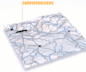 Places with similar names to San Piero a Sieve, Italy :: Disclaimer :: Information on this page comes without warranty of any kind |
||
|
Where is San Piero a Sieve? Elevation and coordinates ::
Latitude (lat): 43°58'0"N Longitude (lon): 11°19'0"E
Elevation (approx.): 227m (map arrows pan, magnifying glasses zoom) |
||
|
Visiting San Piero a Sieve? Hotel/Accommodation ::
Book a hotel in San Piero a Sieve Travel Guide ::
Buy a travel guide for Italy rental cars ::
car rental offers GPS waypoint ::
download a GPX waypoint (PoI) of San Piero a Sieve for your GPS receiver
|
||