|
search place name
|
||
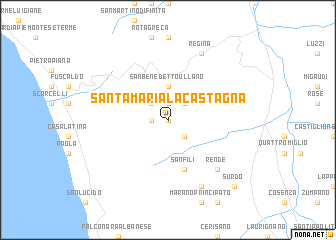
Santa Maria la Castagna (Italy)Santa Maria la Castagna is a town in Italy. An overview map of the region around Santa Maria la Castagna is displayed below.
regional and 3d topo map of Santa Maria la Castagna, Italy ::
Santa Maria la Castagna airports ::
The nearest airport is SUF - Lamezia Terme, located 53.9 km south of Santa Maria la Castagna.
Other airports nearby include CRV - Crotone (92.4 km south east), REG - Reggio Calabria (151.6 km south), TAR - Grottaglie (166.2 km north east), LCC - Lecce (195.8 km north east), Nearby towns ::
San Sisto dei Valdesi (0.0km north) //
La Ferrera (1.4km west) //
Vaccarizzo (1.9km north) //
San Vincenzo la Costa (2.3km south east) //
Parantoro (2.3km north west) //
Montalto Uffugo (2.3km north east) //
Marri (3.7km north) //
San Benedetto Ullano (3.7km north) //
San Fili (5.7km south) //
Rende (7.0km south east) //
Marano Marchesato (7.9km south) //
Regina (7.9km north) //
Surdo (9.4km south east) //
[all distances 'as the bird flies' and approximate] 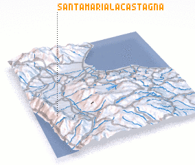 Places with similar names to Santa Maria la Castagna, Italy :: Disclaimer :: Information on this page comes without warranty of any kind |
||
|
Where is Santa Maria la Castagna? Elevation and coordinates ::
Latitude (lat): 39°23'0"N Longitude (lon): 16°8'0"E
Elevation (approx.): 512m (map arrows pan, magnifying glasses zoom) |
||
|
Visiting Santa Maria la Castagna? Hotel/Accommodation ::
Book a hotel in Santa Maria la Castagna Travel Guide ::
Buy a travel guide for Italy rental cars ::
car rental offers GPS waypoint ::
download a GPX waypoint (PoI) of Santa Maria la Castagna for your GPS receiver
|
||