|
search place name
|
||
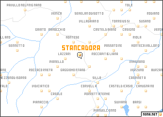
Stancadora (Italy)Stancadora is a town in Italy. An overview map of the region around Stancadora is displayed below.
regional and 3d topo map of Stancadora, Italy ::
Stancadora airports ::
The nearest airport is BLQ - Bologna, located 43.1 km north east of Stancadora.
Other airports nearby include FLR - Firenze (51.3 km south east), PSA - Pisa (75.7 km south west), PMF - Parma (83.8 km north west), FRL - Forli (89.6 km east), Nearby towns ::
Bombiana (2.3km south east) //
Castelluccio (2.7km west) //
Lazzari (2.7km west) //
Gaggio Montano (3.9km south) //
Montese (3.9km north) //
Sassomolare (3.9km north) //
Rocca Pitigliana (4.0km east) //
Pianello (4.4km south west) //
Silla (6.2km south east) //
Corvella (7.5km south) //
Villa dʼAiano (7.5km north) //
Passatore (5.6km east) //
Ranocchio (6.8km north west) //
Castel dʼAiano (6.8km north east) //
Querciola (6.5km south west) //
Lizzano in Belvedere (9.1km south west) //
Sarzana (9.1km north east) //
[all distances 'as the bird flies' and approximate]  Places with similar names to Stancadora, Italy ::
// Sādiān ka Dera (PK)
Disclaimer :: Information on this page comes without warranty of any kind |
||
|
Where is Stancadora? Elevation and coordinates ::
Latitude (lat): 44°14'0"N Longitude (lon): 10°57'0"E
Elevation (approx.): 994m (map arrows pan, magnifying glasses zoom) |
||
|
Visiting Stancadora? Hotel/Accommodation ::
Book a hotel in Stancadora Travel Guide ::
Buy a travel guide for Italy rental cars ::
car rental offers GPS waypoint ::
download a GPX waypoint (PoI) of Stancadora for your GPS receiver
|
||