|
search place name
|
||
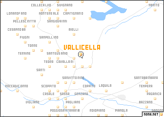
Vallicella (Italy)Vallicella is a town in Italy. An overview map of the region around Vallicella is displayed below.
regional and 3d topo map of Vallicella, Italy ::
Vallicella airports ::
The nearest airport is PSR - Pescara, located 71.1 km east of Vallicella.
Other airports nearby include CIA - Rome Ciampino (92.3 km south west), PEG - Perugia (98.7 km north west), QLT - Latina (104.6 km south), FCO - Rome Fiumicino (112.5 km south west), Nearby towns ::
San Lorenzo (1.9km south) //
Collemusino (1.9km south) //
Pizzoli (1.4km west) //
Arischia (2.3km south east) //
San Pietro (2.3km south west) //
Cavallari (3.3km south west) //
Barete (4.1km west) //
SantʼEusanio (4.1km west) //
Aielli (5.7km north) //
Tarignano (4.5km north west) //
San Vittorino (5.7km south) //
Pozza (6.2km south west) //
Colli (5.5km west) //
Coppito (7.5km south) //
Basanello (5.8km west) //
Teora (5.8km west) //
San Marco (6.9km south west) //
Preturo (7.9km south) //
San Pellino (6.6km north west) //
LʼAquila (8.5km south east) //
Cese (8.5km south west) //
San Giovanni (8.5km north west) //
Colle Paganica (8.5km north west) //
Scoppito (9.2km south west) //
[all distances 'as the bird flies' and approximate]  Places with similar names to Vallicella, Italy ::
// Volossula (RU)
// Vǝlǝsli (AZ)
// Vilssöhl (DE)
// Volzel (DE)
// Filicello (IT)
// Valea Iaşului (RO)
// Valea Uzului (RO)
// Vîlcele (RO)
// Vîlcele (RO)
// Vîlcele (RO)
Disclaimer :: Information on this page comes without warranty of any kind |
||
|
Where is Vallicella? Elevation and coordinates ::
Latitude (lat): 42°26'0"N Longitude (lon): 13°19'0"E
Elevation (approx.): 807m (map arrows pan, magnifying glasses zoom) |
||
|
Visiting Vallicella? Hotel/Accommodation ::
Book a hotel in Vallicella Travel Guide ::
Buy a travel guide for Italy rental cars ::
car rental offers GPS waypoint ::
download a GPX waypoint (PoI) of Vallicella for your GPS receiver
|
||