|
search place name
|
||
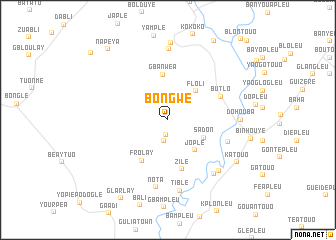
Bongwe (Nimba, Liberia)Bongwe is a town in the Nimba region of Liberia. An overview map of the region around Bongwe is displayed below.
regional and 3d topo map of Bongwe, Liberia ::
Bongwe airports ::
The nearest airport is MJC - Man, located 103.2 km north east of Bongwe.
Other airports nearby include DJO - Daloa (212.5 km east), ROB - Monrovia Roberts Intl (226.5 km west), Nearby towns ::
Diamplay (1.7km south) //
Zonthlo (2.4km south) //
Sadon (4.4km south east) //
Floli (4.5km north east) //
Jople (4.5km south east) //
Gbanwea (5.1km north) //
Frolay (5.4km south west) //
Zile (5.7km south) //
Butlo (6.4km north east) //
Batouapleu (7.1km east) //
Nota (7.7km south) //
Ganhouyé (7.9km south east) //
Nyor Diaplay (8.0km north) //
Tible (8.0km south) //
Souapleu (8.0km south east) //
Dohouba (8.1km east) //
Nyor Butuo (8.6km north) //
Katouo (9.0km south east) //
Blumtuo (10.2km north east) //
Glarlay (10.2km south west) //
Napeya (10.3km north west) //
Deniple (11.4km north west) //
Kpantouopleu (12.4km north east) //
[all distances 'as the bird flies' and approximate] 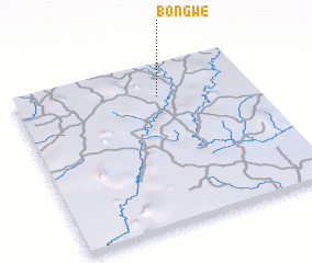 Places with similar names to Bongwe, Liberia ::
Disclaimer :: Information on this page comes without warranty of any kind |
||
|
Where is Bongwe? Elevation and coordinates ::
Latitude (lat): 6°48'15"N Longitude (lon): 8°23'45"W
Elevation (approx.): 258m (map arrows pan, magnifying glasses zoom) |
||
|
Visiting Bongwe? Hotel/Accommodation ::
Book a hotel in Bongwe Travel Guide ::
Buy a travel guide for Liberia rental cars ::
car rental offers GPS waypoint ::
download a GPX waypoint (PoI) of Bongwe for your GPS receiver
|
||