|
search place name
|
||
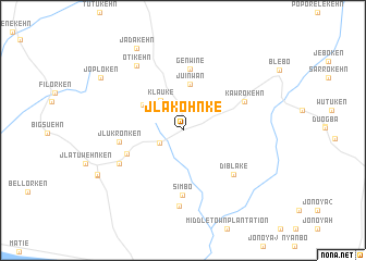
Jlakohnke (Grand Kru, Liberia)Jlakohnke is a town in the Grand Kru region of Liberia. An overview map of the region around Jlakohnke is displayed below.
regional and 3d topo map of Jlakohnke, Liberia ::
Jlakohnke airports ::
The nearest airport is SPY - San Pedro, located 153.3 km east of Jlakohnke.
Nearby towns ::
Gblabroken (2.6km south west) //
Klauke (3.8km north west) //
Juinwan (4.8km north) //
Chiwleken (4.8km north west) //
Elizabeth Collinsville (6.2km west) //
Genwine (6.4km north) //
Jlukronken (6.6km west) //
Simbo (6.7km south) //
Diblake (6.9km south east) //
Kawrokehn (6.9km north east) //
Zolokehn (7.4km south west) //
Juduken (7.8km south) //
Otikehn (8.2km north west) //
Jadakehn (9.7km north west) //
Tolbertville (9.8km south west) //
Gbanken (9.9km south west) //
Joploken (10.0km north west) //
[all distances 'as the bird flies' and approximate] 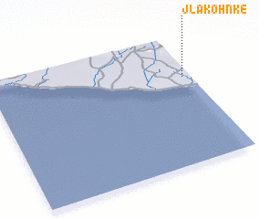 Places with similar names to Jlakohnke, Liberia ::
Disclaimer :: Information on this page comes without warranty of any kind |
||
|
Where is Jlakohnke? Elevation and coordinates ::
Latitude (lat): 4°40'26"N Longitude (lon): 8°2'25"W
Elevation (approx.): 16m (map arrows pan, magnifying glasses zoom) |
||
|
Visiting Jlakohnke? Hotel/Accommodation ::
Book a hotel in Jlakohnke Travel Guide ::
Buy a travel guide for Liberia rental cars ::
car rental offers GPS waypoint ::
download a GPX waypoint (PoI) of Jlakohnke for your GPS receiver
|
||