|
search place name
|
||
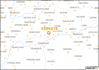
Kpakuta (Lofa, Liberia)Kpakuta is a town in the Lofa region of Liberia. An overview map of the region around Kpakuta is displayed below.
regional and 3d topo map of Kpakuta, Liberia ::
Kpakuta airports ::
The nearest airport is FAA - Faranah, located 206.2 km north west of Kpakuta.
Nearby towns ::
Yokolita Town (1.0km south west) //
Koiblita Town (1.4km east) //
Lovasawu (1.8km west) //
Masamai (2.3km south east) //
Velezala (3.3km east) //
Johnny Town (3.4km west) //
Segbemai (3.7km north) //
Loboba (3.8km north east) //
Jomata (3.9km north west) //
Kolikpakumai (4.1km north west) //
Folemai (4.7km north) //
Zewordamai (4.8km south west) //
Koibatomai (5.5km west) //
Vavamai (6.3km east) //
Maliwalamai (6.6km south west) //
Movimai (6.7km south) //
Bakuma (6.7km east) //
Kotalahun (7.0km west) //
Laboba (7.4km north west) //
Loloyahun (7.4km north) //
Honehun Number Two (7.6km west) //
Koilahun (7.8km north west) //
Zalamai (7.9km east) //
Kologuazu (8.0km south west) //
Tawalahun (8.2km north west) //
Sikamai (8.2km south west) //
Duojalamai (8.3km north east) //
Honehun Number One (8.3km west) //
Wotalah (9.2km north east) //
[all distances 'as the bird flies' and approximate]  Places with similar names to Kpakuta, Liberia ::
Disclaimer :: Information on this page comes without warranty of any kind |
||
|
Where is Kpakuta? Elevation and coordinates ::
Latitude (lat): 8°22'0"N Longitude (lon): 9°56'0"W
Elevation (approx.): 505m (map arrows pan, magnifying glasses zoom) |
||
|
Visiting Kpakuta? Hotel/Accommodation ::
Book a hotel in Kpakuta Travel Guide ::
Buy a travel guide for Liberia rental cars ::
car rental offers GPS waypoint ::
download a GPX waypoint (PoI) of Kpakuta for your GPS receiver
|
||