|
search place name
|
||
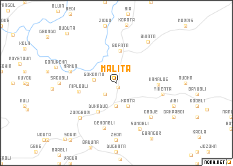
Malita (Grand Bassa, Liberia)Malita is a town in the Grand Bassa region of Liberia. An overview map of the region around Malita is displayed below.
regional and 3d topo map of Malita, Liberia ::
Malita airports ::
The nearest airport is ROB - Monrovia Roberts Intl, located 44.6 km south west of Malita.
Other airports nearby include MLW - Monrovia Spriggs Payne (82.6 km west), Nearby towns ::
Donbwe (0.8km south) //
Tigkpo (2.6km south west) //
Gokonita (3.7km west) //
Baata (3.7km south) //
Kanta (4.1km south east) //
Bofata (5.2km north) //
Dukaduo (5.5km south west) //
Niplobli (6.2km west) //
Kamaloe (6.8km east) //
Demonbli (7.5km south) //
Yiventa (7.6km east) //
Bien (7.6km east) //
Mamun (7.6km west) //
Buabli (7.6km west) //
Gboje (7.8km south east) //
Zorgbari (8.1km south west) //
Sumabli (8.3km south east) //
Bwiata (8.3km north east) //
Buduta (11.3km north west) //
[all distances 'as the bird flies' and approximate] 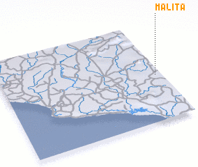 Places with similar names to Malita, Liberia ::
Disclaimer :: Information on this page comes without warranty of any kind |
||
|
Where is Malita? Elevation and coordinates ::
Latitude (lat): 6°28'0"N Longitude (lon): 10°2'0"W
Elevation (approx.): 107m (map arrows pan, magnifying glasses zoom) |
||
|
Visiting Malita? Hotel/Accommodation ::
Book a hotel in Malita Travel Guide ::
Buy a travel guide for Liberia rental cars ::
car rental offers GPS waypoint ::
download a GPX waypoint (PoI) of Malita for your GPS receiver
|
||