|
search place name
|
||
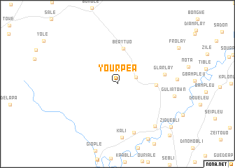
Yourpea (Nimba, Liberia)Yourpea is a town in the Nimba region of Liberia. An overview map of the region around Yourpea is displayed below.
regional and 3d topo map of Yourpea, Liberia ::
Yourpea airports ::
The nearest airport is MJC - Man, located 119.4 km north east of Yourpea.
Other airports nearby include ROB - Monrovia Roberts Intl (211.5 km west), SPY - San Pedro (298.7 km south east), Nearby towns ::
Yopie Podogle (3.1km east) //
Beaytuo (5.7km north) //
Gaadi (6.1km east) //
Glarlay (7.6km east) //
Buzohn (8.1km south) //
Kali (8.6km south) //
Blewali (9.0km south east) //
Saigopleu (10.0km south east) //
Koaro (10.9km south east) //
Ziouebli (10.9km south east) //
Grepleu (11.6km south east) //
[all distances 'as the bird flies' and approximate]  Places with similar names to Yourpea, Liberia ::
Disclaimer :: Information on this page comes without warranty of any kind |
||
|
Where is Yourpea? Elevation and coordinates ::
Latitude (lat): 6°42'42"N Longitude (lon): 8°30'38"W
Elevation (approx.): 244m (map arrows pan, magnifying glasses zoom) |
||
|
Visiting Yourpea? Hotel/Accommodation ::
Book a hotel in Yourpea Travel Guide ::
Buy a travel guide for Liberia rental cars ::
car rental offers GPS waypoint ::
download a GPX waypoint (PoI) of Yourpea for your GPS receiver
|
||