|
search place name
|
||
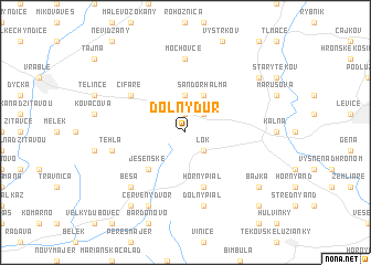
Dolný Ďur (Slovakia)Dolný Ďur is a town in Slovakia. An overview map of the region around Dolný Ďur is displayed below.
regional and 3d topo map of Dolný Ďur, Slovakia ::
Dolný Ďur airports ::
The nearest airport is PZY - Piestany, located 66.0 km north west of Dolný Ďur.
Other airports nearby include SLD - Sliac (70.2 km north east), BTS - Bratislava M R Stefanik (92.1 km west), BUD - Budapest Ferihegy (104.1 km south east), VIE - Vienna Schwechat (140.2 km west), Nearby towns ::
Horný Dʼur (1.9km north) //
Rohožnica (2.2km north east) //
Lok (2.2km south east) //
Chladno (3.7km north) //
Sándorhalma (3.9km north) //
Jesenské (4.5km south west) //
Iňa (4.5km south west) //
Horný Pial (5.7km south) //
Čifáre (5.2km north west) //
Mochovce (7.4km north) //
Tehla (5.3km west) //
Dolný Pial (7.5km south) //
Beša (6.7km south west) //
Červený Dvor (7.8km south) //
Nový Tekov (7.4km north east) //
Bajka (7.4km south east) //
Barak Majer (8.3km south west) //
Ondrejovce (8.9km south east) //
[all distances 'as the bird flies' and approximate] 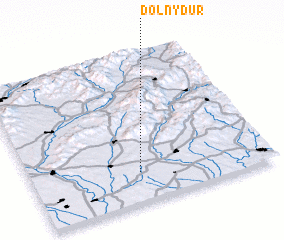 Places with similar names to Dolný Ďur, Slovakia ::
Disclaimer :: Information on this page comes without warranty of any kind |
||
|
Where is Dolný Ďur? Elevation and coordinates ::
Latitude (lat): 48°12'0"N Longitude (lon): 18°27'0"E
Elevation (approx.): 190m (map arrows pan, magnifying glasses zoom) |
||
|
Visiting Dolný Ďur? Hotel/Accommodation ::
Book a hotel in Dolný Ďur Travel Guide ::
Buy a travel guide for Slovakia rental cars ::
car rental offers GPS waypoint ::
download a GPX waypoint (PoI) of Dolný Ďur for your GPS receiver
|
||