|
search place name
|
||
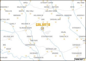
Galanta (Slovakia)Galanta is a town in Slovakia. An overview map of the region around Galanta is displayed below.
regional and 3d topo map of Galanta, Slovakia ::
Galanta airports ::
The nearest airport is BTS - Bratislava M R Stefanik, located 37.6 km west of Galanta.
Other airports nearby include PZY - Piestany (48.0 km north), VIE - Vienna Schwechat (85.9 km west), SLD - Sliac (115.7 km north east), BRQ - Turany (129.8 km north west), Nearby towns ::
Hody (NaNkm north) //
Nebojsa (2.2km north east) //
Gáň (3.7km north) //
Brakoň (3.9km north) //
Štefánikovo (3.9km south) //
Matúškovo (3.9km south) //
Veľká Mača (5.7km north) //
Zánska Lúka (5.2km north east) //
Košúty (5.2km south west) //
Mostová (6.1km south west) //
Sládkovičovo (4.9km west) //
Malá Mača (5.3km west) //
Čierny Brod (6.7km south west) //
Dolná Streda (7.8km north) //
Váhovce (7.4km north east) //
Malý Háj (8.3km north west) //
Čierna Voda (8.3km south west) //
[all distances 'as the bird flies' and approximate] 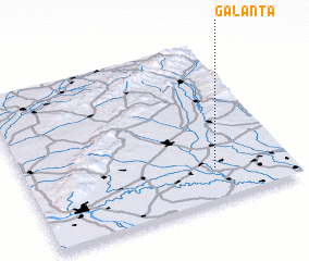 Places with similar names to Galanta, Slovakia ::
Disclaimer :: Information on this page comes without warranty of any kind |
||
|
Where is Galanta? Elevation and coordinates ::
Latitude (lat): 48°12'0"N Longitude (lon): 17°43'0"E
Elevation (approx.): 116m (map arrows pan, magnifying glasses zoom) |
||
|
Visiting Galanta? Hotel/Accommodation ::
Book a hotel in Galanta Travel Guide ::
Buy a travel guide for Slovakia rental cars ::
car rental offers GPS waypoint ::
download a GPX waypoint (PoI) of Galanta for your GPS receiver
|
||