|
search place name
|
||
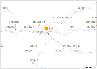
Huta (Slovakia)Huta is a town in Slovakia. An overview map of the region around Huta is displayed below.
regional and 3d topo map of Huta, Slovakia ::
Huta airports ::
The nearest airport is SLD - Sliac, located 37.7 km south west of Huta.
Other airports nearby include TAT - Poprad Tatry (57.0 km north east), KSC - Kosice (122.9 km east), PZY - Piestany (130.6 km west), KRK - Krakow Balice (142.9 km north), Nearby towns ::
Hronec (0.0km north) //
Piesok (1.2km west) //
Valaská (1.9km north) //
Štiavnička (2.4km west) //
Horná Lehota (4.4km north west) //
Podbrezová (4.1km north west) //
Bystrá (5.7km north) //
U Medveďov (6.1km south east) //
Vajsková (5.2km west) //
Brezno (5.2km east) //
Krám (6.7km south east) //
Osrblie (6.7km south west) //
Mýto pod Ďumbierom (6.7km north east) //
Dolná Lehota (6.1km north west) //
Dolina (7.8km south) //
Jergov (7.4km south east) //
Vydrovo (7.4km south east) //
Tri Vody (8.9km south west) //
[all distances 'as the bird flies' and approximate] 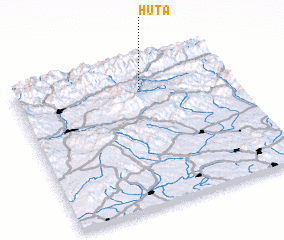 Places with similar names to Huta, Slovakia ::
Disclaimer :: Information on this page comes without warranty of any kind |
||
|
Where is Huta? Elevation and coordinates ::
Latitude (lat): 48°48'0"N Longitude (lon): 19°35'0"E
Elevation (approx.): 579m (map arrows pan, magnifying glasses zoom) |
||
|
Visiting Huta? Hotel/Accommodation ::
Book a hotel in Huta Travel Guide ::
Buy a travel guide for Slovakia rental cars ::
car rental offers GPS waypoint ::
download a GPX waypoint (PoI) of Huta for your GPS receiver
|
||