|
search place name
|
||
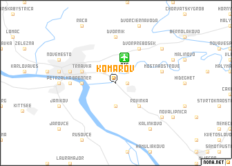
Komárov (Slovakia)Komárov is a town in Slovakia. An overview map of the region around Komárov is displayed below.
regional and 3d topo map of Komárov, Slovakia ::
nearby GPS traces from timatio ::
Komárov airports ::
The nearest airport is BTS - Bratislava M R Stefanik, located 4.2 km north of Komárov.
Other airports nearby include VIE - Vienna Schwechat (47.0 km west), PZY - Piestany (71.8 km north east), BRQ - Turany (119.2 km north), PRV - Prerov (144.5 km north), Nearby towns ::
Podunajské Biskupice (1.2km east) //
Prievoz (2.2km north west) //
Vrakuňa (2.2km north east) //
Kötélszer Pusta (3.7km south) //
Rovinka (4.5km south east) //
Brenner (3.7km west) //
Trnávka (4.1km north west) //
Dvor Prebosek (6.1km north east) //
Ovsište (4.9km west) //
Dvorník (7.4km north) //
Most na Ostrove (5.3km east) //
Nivy (5.3km west) //
Kalinkovo (8.3km south east) //
Nové Košariská (7.4km south east) //
Jánošíková (7.4km south east) //
Ivanka pri Dunaji (7.4km north east) //
[all distances 'as the bird flies' and approximate] 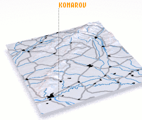 Places with similar names to Komárov, Slovakia ::
Disclaimer :: Information on this page comes without warranty of any kind |
||
|
Where is Komárov? Elevation and coordinates ::
Latitude (lat): 48°8'0"N Longitude (lon): 17°12'0"E
Elevation (approx.): 132m (map arrows pan, magnifying glasses zoom) |
||
|
Visiting Komárov? Hotel/Accommodation ::
Book a hotel in Komárov Travel Guide ::
Buy a travel guide for Slovakia rental cars ::
car rental offers GPS waypoint ::
download a GPX waypoint (PoI) of Komárov for your GPS receiver
|
||