|
search place name
|
||
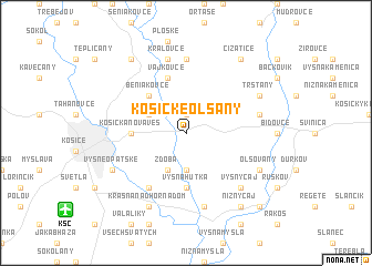
Košické Olšany (Slovakia)Košické Olšany is a town in Slovakia. An overview map of the region around Košické Olšany is displayed below.
regional and 3d topo map of Košické Olšany, Slovakia ::
Košické Olšany airports ::
The nearest airport is KSC - Kosice, located 11.2 km south west of Košické Olšany.
Other airports nearby include TAT - Poprad Tatry (89.7 km north west), DEB - Debrecen (139.8 km south), RZE - Rzeszow Jasionka (160.6 km north), SUJ - Satu Mare (161.7 km south east), Nearby towns ::
Rozhanovce (1.9km north) //
Byster (3.7km south) //
Polianka (3.7km south) //
Zdoba (3.9km south) //
Hrašovík (3.1km north west) //
Beniakovce (4.4km north west) //
Vyšná Hutka (5.6km south) //
Košická Nová Ves (3.7km west) //
Vajkovce (5.7km north) //
Opátska (6.1km south west) //
Chrastné (7.4km north) //
Nižná Hutka (7.5km south) //
Kráľovce (7.5km north) //
Ďurdʼošík (5.2km east) //
Vyšný Čaj (6.7km south east) //
Krásna nad Hornádom (7.8km south) //
Olšovany (6.1km south east) //
Vyšné Opátske (6.1km south west) //
Trsťany (6.1km north east) //
Nižný Čaj (8.3km south east) //
Čižatice (8.3km north east) //
Budimír (8.3km north west) //
Blažice (8.9km south east) //
[all distances 'as the bird flies' and approximate]  Places with similar names to Košické Olšany, Slovakia :: Disclaimer :: Information on this page comes without warranty of any kind |
||
|
Where is Košické Olšany? Elevation and coordinates ::
Latitude (lat): 48°44'0"N Longitude (lon): 21°21'0"E
Elevation (approx.): 220m (map arrows pan, magnifying glasses zoom) |
||
|
Visiting Košické Olšany? Hotel/Accommodation ::
Book a hotel in Košické Olšany Travel Guide ::
Buy a travel guide for Slovakia rental cars ::
car rental offers GPS waypoint ::
download a GPX waypoint (PoI) of Košické Olšany for your GPS receiver
|
||