|
search place name
|
||
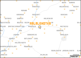
Malá Lehôtka (Slovakia)Malá Lehôtka is a town in Slovakia. An overview map of the region around Malá Lehôtka is displayed below.
regional and 3d topo map of Malá Lehôtka, Slovakia ::
Malá Lehôtka airports ::
The nearest airport is SLD - Sliac, located 37.3 km east of Malá Lehôtka.
Other airports nearby include PZY - Piestany (63.7 km west), OSR - Ostrava Mosnov (111.0 km north), PRV - Prerov (117.8 km north west), TAT - Poprad Tatry (120.3 km east), Nearby towns ::
Hradec (1.2km east) //
Veľká Lehôtka (2.2km south east) //
Prievidza (2.4km west) //
Veľká Čausa (3.1km north east) //
Necpaly nad Nitrou (3.1km north west) //
Malá Čausa (4.4km north east) //
Sebedražie (4.4km south west) //
Lipník (4.1km north east) //
Brezany (5.7km north) //
Nedožery (5.7km north) //
Cigeľ (5.7km south) //
Lazany (6.1km north west) //
Chrenovec-Brusno (5.2km east) //
Brusno (5.2km east) //
Betlehem (6.7km south west) //
Malá Lehota (8.3km south west) //
Poruba (8.9km north west) //
[all distances 'as the bird flies' and approximate] 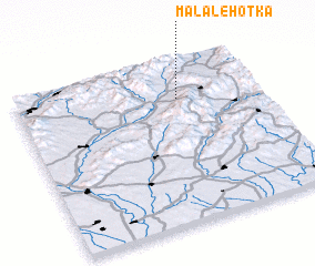 Places with similar names to Malá Lehôtka, Slovakia :: Disclaimer :: Information on this page comes without warranty of any kind |
||
|
Where is Malá Lehôtka? Elevation and coordinates ::
Latitude (lat): 48°46'0"N Longitude (lon): 18°40'0"E
Elevation (approx.): 351m (map arrows pan, magnifying glasses zoom) |
||
|
Visiting Malá Lehôtka? Hotel/Accommodation ::
Book a hotel in Malá Lehôtka Travel Guide ::
Buy a travel guide for Slovakia rental cars ::
car rental offers GPS waypoint ::
download a GPX waypoint (PoI) of Malá Lehôtka for your GPS receiver
|
||