|
search place name
|
||
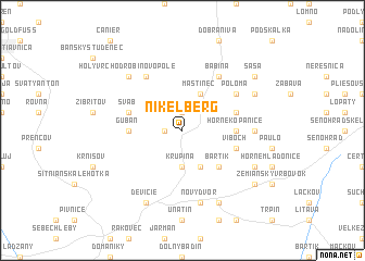
Nikelberg (Slovakia)Nikelberg is a town in Slovakia. An overview map of the region around Nikelberg is displayed below.
regional and 3d topo map of Nikelberg, Slovakia ::
Nikelberg airports ::
The nearest airport is SLD - Sliac, located 28.7 km north of Nikelberg.
Other airports nearby include PZY - Piestany (95.4 km west), BUD - Budapest Ferihegy (106.2 km south), TAT - Poprad Tatry (115.6 km north east), BTS - Bratislava M R Stefanik (139.6 km west), Nearby towns ::
Vajsov (1.2km west) //
Široké Lúky (1.9km north) //
Krupina (3.7km south) //
Briač (3.9km south) //
Mastinec (3.9km north) //
Bártik (4.5km south east) //
Horné Kopanice (3.7km east) //
Gubáň (3.7km west) //
Rusniak (4.1km south east) //
Víboch (4.1km south east) //
Šváb (4.1km north west) //
Brezová (4.1km north east) //
Babiná (6.1km north east) //
Poloma (5.2km north east) //
Durica (6.1km north west) //
Černič (4.9km east) //
Nový Dvor (7.5km south) //
Holý Vrch Odrobinovo Pole (6.7km north west) //
Čekovce (6.2km south east) //
Bzovík (7.8km south) //
Horný Jalšovík (7.8km south) //
Devičie (7.8km south) //
Bzovská Lehôtka (6.2km north east) //
Dolné Mladonice (7.4km south east) //
Sása (7.4km north east) //
[all distances 'as the bird flies' and approximate]  Places with similar names to Nikelberg, Slovakia ::
// Nøkleberg (NO)
Disclaimer :: Information on this page comes without warranty of any kind |
||
|
Where is Nikelberg? Elevation and coordinates ::
Latitude (lat): 48°23'0"N Longitude (lon): 19°4'0"E
Elevation (approx.): 370m (map arrows pan, magnifying glasses zoom) |
||
|
Visiting Nikelberg? Hotel/Accommodation ::
Book a hotel in Nikelberg Travel Guide ::
Buy a travel guide for Slovakia rental cars ::
car rental offers GPS waypoint ::
download a GPX waypoint (PoI) of Nikelberg for your GPS receiver
|
||