|
search place name
|
||
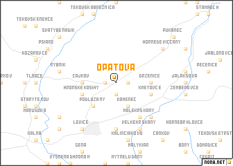
Opatová (Slovakia)Opatová is a town in Slovakia. An overview map of the region around Opatová is displayed below.
regional and 3d topo map of Opatová, Slovakia ::
Opatová airports ::
The nearest airport is SLD - Sliac, located 53.3 km north east of Opatová.
Other airports nearby include PZY - Piestany (71.7 km north west), BUD - Budapest Ferihegy (104.4 km south east), BTS - Bratislava M R Stefanik (107.5 km west), TAT - Poprad Tatry (146.5 km north east), Nearby towns ::
Svätý Kríž (1.9km south) //
Tekovská Nová Ves (1.2km west) //
Gondovo (1.2km east) //
Kamenec (3.9km south) //
Podlužany (4.5km south west) //
Čajkov (3.7km west) //
Drženice (3.7km east) //
Hronské Kosihy (4.1km south west) //
Kmeťovce (4.1km south east) //
Malé Krškany (6.1km south east) //
Pustatina Čuda (7.4km south) //
Horša (6.7km south east) //
Veľké Krškany (7.8km south) //
Levice (8.3km south west) //
Horné Devičcany (7.4km north east) //
Dolné Devičany (7.4km north east) //
Devičany (7.4km north east) //
[all distances 'as the bird flies' and approximate]  Places with similar names to Opatová, Slovakia ::
Disclaimer :: Information on this page comes without warranty of any kind |
||
|
Where is Opatová? Elevation and coordinates ::
Latitude (lat): 48°17'0"N Longitude (lon): 18°39'0"E
Elevation (approx.): 187m (map arrows pan, magnifying glasses zoom) |
||
|
Visiting Opatová? Hotel/Accommodation ::
Book a hotel in Opatová Travel Guide ::
Buy a travel guide for Slovakia rental cars ::
car rental offers GPS waypoint ::
download a GPX waypoint (PoI) of Opatová for your GPS receiver
|
||