|
search place name
|
||
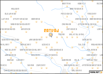
Ratvaj (Slovakia)Ratvaj is a town in Slovakia. An overview map of the region around Ratvaj is displayed below.
regional and 3d topo map of Ratvaj, Slovakia ::
Ratvaj airports ::
The nearest airport is KSC - Kosice, located 50.5 km south of Ratvaj.
Other airports nearby include TAT - Poprad Tatry (70.2 km west), RZE - Rzeszow Jasionka (125.3 km north east), KRK - Krakow Balice (148.0 km north west), DEB - Debrecen (183.6 km south), Nearby towns ::
Bodovce (1.2km west) //
Babin Potok (1.2km east) //
Podhradisko (2.2km north east) //
Hubošovce (2.2km south east) //
Šarišské Sokolovce (2.4km west) //
Terňa (2.4km east) //
Svätý ďur (3.7km south) //
Hradisko (3.1km north east) //
Uzovce (3.9km south) //
Mošurov (3.6km east) //
Jakubovany (4.1km south west) //
Gregorovce (5.7km south) //
Ambrušovce (6.1km north west) //
Závadka (5.2km north east) //
Malý Slivník (4.9km east) //
Veľký Šariš (7.4km south) //
Žatkovce (5.2km east) //
Geraltov (5.2km east) //
Baranie (6.6km north west) //
Kanaš (7.8km south) //
Záhradné (6.1km south east) //
Fričkovce (8.3km north east) //
Osikov (7.4km north east) //
Šarišské Michalʼany (7.4km south west) //
Medzany (8.3km south west) //
[all distances 'as the bird flies' and approximate]  Places with similar names to Ratvaj, Slovakia ::
Disclaimer :: Information on this page comes without warranty of any kind |
||
|
Where is Ratvaj? Elevation and coordinates ::
Latitude (lat): 49°7'0"N Longitude (lon): 21°12'0"E
Elevation (approx.): 479m (map arrows pan, magnifying glasses zoom) |
||
|
Visiting Ratvaj? Hotel/Accommodation ::
Book a hotel in Ratvaj Travel Guide ::
Buy a travel guide for Slovakia rental cars ::
car rental offers GPS waypoint ::
download a GPX waypoint (PoI) of Ratvaj for your GPS receiver
|
||