|
search place name
|
||
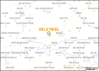
Veľký Biel (Slovakia)Veľký Biel is a town in Slovakia. An overview map of the region around Veľký Biel is displayed below.
regional and 3d topo map of Veľký Biel, Slovakia ::
Veľký Biel airports ::
The nearest airport is BTS - Bratislava M R Stefanik, located 12.6 km south west of Veľký Biel.
Other airports nearby include PZY - Piestany (56.9 km north east), VIE - Vienna Schwechat (60.5 km west), BRQ - Turany (115.1 km north west), PRV - Prerov (134.5 km north), Nearby towns ::
Malý Biel (0.0km north) //
Horný Dvor (1.9km north) //
Senec (2.5km east) //
Nová Ves pri Dunaji (3.7km south) //
Tureň (3.9km south) //
Dedinka pri Dunaji (3.9km south) //
Vlky (5.6km south) //
Malý Madaras (7.4km south) //
Matka Božia (5.3km east) //
Chorvátský Grob (5.3km west) //
Bernolákovo (5.3km west) //
Hrubý Šúr (6.7km south east) //
Blatné (6.7km north east) //
Kostolná pri Dunaji (6.2km south east) //
Malý Šúr (6.2km south east) //
Janíky (7.8km south) //
Tomášov (7.8km south) //
Malinovo (7.4km south west) //
Hurbanova Ves (8.3km south east) //
Viničné (7.4km north west) //
[all distances 'as the bird flies' and approximate] 
Disclaimer :: Information on this page comes without warranty of any kind |
||
|
Where is Veľký Biel? Elevation and coordinates ::
Latitude (lat): 48°13'0"N Longitude (lon): 17°22'0"E
Elevation (approx.): 126m (map arrows pan, magnifying glasses zoom) |
||
|
Visiting Veľký Biel? Hotel/Accommodation ::
Book a hotel in Veľký Biel Travel Guide ::
Buy a travel guide for Slovakia rental cars ::
car rental offers GPS waypoint ::
download a GPX waypoint (PoI) of Veľký Biel for your GPS receiver
|
||